just what we needed
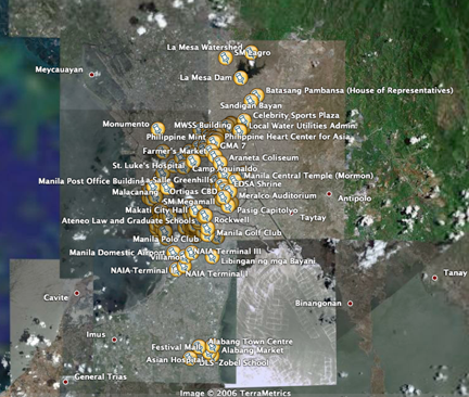
The new high res sat images of Metro Manila on Google Earth has made us crazy. Roby Alampay and I have decided that we need a central repository for all Google Earth data on the Philippines. He's set up a wiki called GoogleEarthPhilippines and uploaded a few kmz files to mark up your Google Earth.
So far we've got all the MRT/LRT stations, a partial of MM landmarks, a partial of UP Diliman (someone put in the dorms please), a partial of schools, etc.
We can't do this on our own so we're inviting everyone to come and upload your own kmz files. Visit the wiki here leave some comments or send us a wishlist of what you want to see marked.


14 comments:
Hi Urbano,
Naga unfornately was not among the areas covered by Google Earth's new hi-res maps.
An enterprising former colleague, who's now Manila-based has been tinkering with what we have. A sample can be found here (sorry for the long URL) http://bbs.keyhole.com/ubb/showthreaded.php/Cat/0/Number/470380/an/0/page/0#470380.
I know we can do a lot more with hi-res Google Earth maps. Do you have any idea through which we can bring this to the Google Earth people's attention?
Thanks.
Such a cool new toy indeed!
Thanks for the heads up, I've always been fascinated with maps--
Ideas/wishlist:
1- university tour
2- bodies of water (lakes, rivers, estuaries)
3- slum areas
4- solid waste management route
5- churches
6- malls (maybe to emphasize that we don't need more of them!)
7- jeepney, bus routes
8- comparative beaches
Willy,
I've tried asking Google to put in more Philippine data but Google Earth uses NavtraQ data -and we have to wait till NavtraQ (a private company) updates all their data.
Eventually, all the geospatial data will be available online: see this site
P.S. -I can't seem to connect to the gis.naga.gov link that shows up on the google maps marker you sent.
Jo,
Thanks for the suggestions. Our latest update of the metro manila landmarks kml file has subgroupings (churches, parks, malls and markets, etc.)
check the link out on google maps. (Note: Make sure you choose "satellite" and "maps" on the google maps interface -zoom in and then click on the list to the right.) -still has kinks we need to iron out.
It's operational now.:)
I guess the city hall server went offline during the weekend. I wasn't able to access the website myself.
Willy,
that is sooo cool. with your permission, can we upload it to Google Earth Philippines?
I'd also like to post a screen grab of the population visualization on Metro Manila Makeover and link back to the kmz file.
good to know our GIS is moving forward. I hope Naga is using it to improve governance.
(btw, one more favor: where can i get a copy of Mayor Jesse's presentation in Vancouver?)
urbano
i'm going gaga over google earth's new hi-res maps. i hope it gets to cover more areas within the country.
great work on the repository.
thanks daniel.
GE is pretty addicting. Its like driving through the city without the traffic!
Please contribute to the wiki!
No problemo. Am sure my colleagues past and present at the i-Gov team wouldn't mind :)
I'll email you both his Word and Powerpoint materials.
I intend to maximize use of our GIS resources, particularly now that I spend half of my time with the city planning office.
My journey has come full circle:) CPDO is my original mother unit when I joined city hall in '92. I will blog about it sometime this week.
willy,
would you know if where I can get ArcGIS shapefiles /datasets for the philippines?
I've been looking.
dubWilly,
Thanks for sending Mayor Jesse's presentation. I hope we can replicate Naga's model of participatory governance in all our localities.
btw, new post on Metro Manila Makeover about the Naga City population kmz.
Also made the file available on Google Earth Philippines.
Thanks again!
(oops -forgive the typo)
Hi Urbano,
I lifted the following post from the GIS section of our Naga Community Forum at http://www.naga.gov.ph/forum/viewtopic.php?p=18587#18587.
Maybe we can use them to convince the Google Earth people and their satellite provide to redo the Naga shots :)
Willy
====================================
jessie wrote:
Philippine areas with high-resolution images
Source: http://vaes9.codedgraphic.com/
It says there na Naga is one of the cities with High-res Image, pero PILI-OCAMPO-BAAO area ang may high-res image!! Sabi ko na nga ba, nag-off lang ning kapirang kilometro to the south-east si kua kang satellite.. waahhhh! siguro, sala si coordinates na tinao ni adolf?? waaahhh!!!
====================================
I could help you with the UP dorms just let me know how it could be done.
Have you visited the database of heritage structures we are building in http://heritageconservation.wordpress.com? Maybe we could include those as well.
Post a Comment