7.30.2006

unrelated. relevant.

pardon the unrelated post. this is my own un-silent scream as I hold my own child closer.


fifty-four today. a sunday.

how many children does it take
to make you notice, america?
how many of our children?

do they have to dance
and prance about in pageants?
must they be killed
by their own mothers
before you take notice?
must they return unborn
before you value them?

how many children does it take?
how many of our children
is it worth to achieve "sustainable peace"?

will anyone be left to sustain it?

(I know you have sent your own
for reasons I still cannot understand
and I grieve your loss as much.
they were grown men of twenty years or more.
at least you saw the pleasure of their play
before you lost them.)

will five of our four year olds
suffice for one of yours?

how many children does it take, america?
how many of our children
before you say enough.

enough.

and leave us time to hold those
still breathing.

--


with prayers to the one who called peacemakers "blessed"
and blessed the little ones of Judea, Samaria and Nazareth.

Benjamin dela Pena
July 30, 2006

7.28.2006

learning from others

Carol Coletta's CEOs for Cities has a great radio show (available as a podcast via iTunes), runs a great website, commisions great research and releases a great newsletter.

They are (in their own words) "..a national network of urban leaders speeding innovation in cities. It is the only organization that brings together mayors, university officials, corporate executives foundation presidents, and business and civic leaders to tackle issues affecting the future of U.S. cities."

Although US centric -much of what they discuss would be of great help to progressive city mayors and managers back home. Here's a snippet from the June 5, 2006 newsletter [my notes in brackets]:

What We Know About Urban Success…

Based on earlier work for our organization by Bob Weissbourd and Chris Berry, we know that:
  • The fates of cities and their suburbs are inextricably tied. They succeed or fail together. [The near suburbs of Northern Cavite and Southern Rizal, pay heed! Subic and Clark, pay attention!]
  • Increasing per capita income is a better measure of the success of cities than is increasing population.
  • The best predictor of a city’s economic success is the percentage of college-educated people among its citizens. [I think we are the 6th largest producer of college graduates. - Whether they are on par with the best is the question. How we can keep and employ them is the challenge.]
  • The isolation of Blacks and Hispanics has a negative and significant effect on a city's income growth. [So who are the marginalized and disenfranchised in the Metro Manila? We don't segregate by race or regional identity -but we do segregate by income.]
  • Income inequality has a negative effect on urban economic growth. [See my last comment.]
more...
Go visit. Lots of good stuff.

hitting the books: two servings

I've promised a urban activists book guide for sometime. I've fumbled with it and was trying to decide whether to list down the classic studies on urbanism, or just stay with practical readings that will hopefully lead you to other readings.

Being painfully aware of the dangers of dilettantish advocacy, I wanted to give a stronger foundation in the basics of urban history and dynamics. But then that road is too academic -and this is a blog on urban issues, not a course in urban planning.

So I think I'll forego the rationalization and just post about books I find interesting -which hopefully you will find interesting too. The caveat is, urban planning books are so hard to come by (unlike architecture and design books which seem to be in vogue) although the rise of New Urbanism has certainly increased the number of covers. Esoteric as they seem to be, there is an almost epicurean delight in finding one or two volumes lost in the stack of used or unsold tomes.

Here are two. The first is relatively accesible (bunny slope, if you will) called How Cities Work by Alex Marshall. Alex's book is a great counterpoint to the dogma of the new urbanists - citing their best contributions and questioning some of their assumptions. His ideas and insights are born of practical observations. Best of all, you can read almost his whole book through this section of his site. (I've had the pleasure of meeting and sharing a panel presentation with Alex.)

The more geekish (esp. Wolfram fans) will appreciate Cities and Complexity by Michael Batty (of Space Syntax fame) director of the Center for Advance Spatial Analysis. Although the jury is still out on the merits of space syntax -this book will give you a great introduction on how computers and the theories of emergence are helping us to understand (and hopefully manage) our cities better. Again, sections of the book will soon be available here.

7.25.2006

going mental 4: walled out and edgeless


Going back to our conceptual analysis of Metro Manila. Take a look at the first image.

Where does metro manila physically end? I know there are the political boundaries of the NCR cities and municipalities -but as far as actual scope of urbanization, where does it end? When do you know you've left the city and have entered the countryside?

Cavite, Laguna and Batangas are becoming as intensely urban as southern Metro Manila and the metropolis has become edgeless. (Calabarzon actually has a larger population than the NCR. The Southern Tagalog urbanized population is also growing faster than the NCR.)

This blurred edge was also hastened by the loophole in Agrarian Reform Law that allowed landowners to keep their holdings if the land was no longer in agricultural use. Most of Cavite's once productive farmlands are now zoned for other uses (commercial, industrial or residential).

Our metropolis not only sprawls north, south and east but it also is largely homogenous - residential subdivision after residential subdivision -variagated only only in housing size and income.

It is income that largely differentiates and defines our residential districts. The metropolis is quartered by gated communities that often frustrate effective transportation and traffic patterns.

The second image shows the differing grain in house size that also stands in for the economic strata of the residents -from Ayala Alabang (A), to BF Paranaque (A and upper B) to Taguig (C & D).

What makes these gated villages different from the rest of the metropolis is that value of land inside the gates tends to appreciate faster than the rest of the metropolis. (And yet the size of the middle and upper class does not seem to be expanding so it makes you wonder if the rich are only selling to themselves.)

In cities that grew up before the automobile (i.e. -their transport options included walking, animal drawn carriages or trains), you can take the land values map and it will almost mirror the relative heights of buildings. More expensive land tends to encourage taller buildings. Land that is also more connected by infrastructure (i.e. -the closer you are to a mass transit station) also tends to command a higher price.

Two forces drive the alternative effect in our metropolis: In a polycentric city like ours (like LA and Atlanta), the land values correspond to preferred elite communities -and reflect the value in shared amenities that the original developer put in (i.e. -roads, sewer, water, trees, parks etc. -as well as security). The other driving force is adjacency to high value commercial property (think the gated communities of the Makati CBD or Greenhills and the Valle Verdes) -or a private amenity such as a golf course or a premier university (think Wakwak, Ayala Heights or Ayala Alabang.)

Our gated communities also echo the historic intra of the Intramuros. To the extramuros (the arraballes of old) belong the great unwashed -the service people and the crop growers who tend the fields and businesses owned by the elite living inside the gates. (See Carlos' outstanding essay on the demise of the mestizo class.)

It also reflects the inverse level of investment (by the national and local governments) in public facilities outside the gated communities. While the edgeless sprawling urbanity is the built on the relative weakness of the agrarian economy in lands adjacent to the metropolis.

The good news is gated communities are not unique to Metro Manila. Other cities suffer the same kind of economic segregation and are searching for politically palatable (read: incentives) options to get the gates open. We will learn from their innovations.

7.14.2006

a few good words

More than a few actually. This blog got featured in the July 2006 edition of "The magazine for filipinos worldwide." Big thanks to Raymond Virata and Filipinas Magazine for the coverage. Raymond is the Art Director of Filipinas and writes his own blog called Cross Postings and is member of the pinoy expat design community based in San Francisco.
If you can get yourself a copy of the edition - the article reveals my double super sekrit identity. (Like it matters.)
Special thanks to Carlos and Juned for the very kind words.
All this on the heels of INQ7's feature story about Google Earth Philippines and Philippines Makeover.
It raineth and poureth on this urban issues soapbox.

(Full disclosure: Juned and Raymond are friends of mine from high school.)

7.12.2006

time out: whatever happened to subic?


The image to the right is the original masterplan for the Subic Freeport by Kenzo Tange and Associates. It was proposed back in the heady days when Dick Gordon was chief cheerleader for the port and when APEC put Subic in the spotlight and the leaders of the 40% of the world's population (and, back then, 56% of the global GDP) signed the 1996 Subic Declaration (which was ironically titled "From Vision to Action").

Subic back then was supposed to be our answer to Singapore and was meant to eclipse the port of Hongkong and rival Malaysia's Multimedia Super Corridor. The masterplan shows an intense CBD style development with a tall central spine and a strong sea-to-mountain visual axis.

Unfortunately, because of internecine politicking the the vision seems to have died on the vine. The second image shows the Freeport now. True, Subic is still getting the Subic-Clark Expressway and that $215 million container port and its industrial core is expanding, albeit by fits and starts.

The strategic question that Subic must answer is what role will it play in the megalopolis when the expressway and northrail finally connect Metro Manila with Clark and the freeport. Will it just be the overflow for Manila's port traffic? An alternative to the industrial sites in Cavite and Batangas? Will it just be the gateway to central luzon - and be another export processing node? What key niche will it serve in (GMA's) "urban beltway"?

The current economic strategy seems to be following a 1970's-80's, export led development track. Get factories, low-cost labor, then build from there. Great, except now you're competing with China.

Maybe Subic should rethink its strategy. It should start looking at post industrial strategies that leapfrog the export-led, labor infrastructure and jump instead to the growing business process outsourcing industries and IT and biotech industries. This is also the new paradigm in urban planning.

In the industrial age, physical infrastructure -access to road, rail, air -was the guarantor of urban economic success. Hence the explosive growth of port cities, and consequently the heavy investment in physical infrastructure from the 20's to the 80's. The mantra of export led development also preached low-cost labor as the competitive advantage

In the new paradigm -it is connectivity by bits -access to the information as well as investments in human capital that is the edge. Creativity trumps low cost labor. Cities are pursuing creative industries - and attracting creative talent as part of the economic strategy. So rather than investing in industrial parks and ports, cities are investing in livable downtowns and arts districts and in broadband and fiber optics. Several cities (Philadelphia, San Francisco) are opening up citywide wifi access. -Apart from asking "What will make it easier to do business here?" cities are asking, "How do we get young people to live and work here?" Instead of investing in industrial muscle, cities are looking for enriching intellectual capital.

The new success stories are Bangalore, Portland, Seattle, Austin. (Singapore knows that it must attract the creative class to retain its competitive edge and is investing heavily in educating for creativity.)

I wrote about Subic in a very early post. I posited some questions that I think are still valid, if Subic is to become more than just another industrial park:

  • What kind of city are we building?
  • Who will live here? Where will they live?
  • What will they do/ Where will they work?
  • How will people travel to get to where they work?
  • Where will people go to buy their daily needs?
  • What kind of place will this be?
I will add three more questions:

  • How do we attract the highly educated, 25-35 year olds (the cadre of the tech industry and breeding ground of entrepreneurs) to live, work and invest in Subic?
  • How do we make this a center of research?
  • How do we make Subic a showcase of sustainable urban development- and have it join the vanguard cities of the 21st century, post-industrial economies?
I see no reason why Subic cannot compete in the BPO/Call Center market. This would be a good starting point. They can convert those old hotels (which aren't doing very well, anyway) into call centers. The existing infrastructure of underground conduits will make laying a high speed fiber optic backbone easier. The natural environment would be a great come-on. You could have young professionals (call center workers -or back office techies) working in Subic during the weekdays and taking the ferry back to Manila on weekends. (They can work at night -and party on the beach, or hike in the jungles in the daytime.)

The BPO investors will also appreciate the access to watersports and hiking and nature. They could very well be persuaded to open up more companies tech companies -beyond BPOs and call centers.

The kind of buildings and (floorplates) a tech based metropolitan economy requires a very different spatial plan -a different urban plan and strategy. One that pays more attention to placemaking and quality of life and livability. One that looks ahead of the curve and asks "What kind of city will this be?"

7.10.2006

going mental (3.a) -confluences and waterfronts


above: conceptual map of metro manila with
suggested areas to celebrate the waterfront.


below: four opportunity sites at the confluence
of the pasig and the san juan rivers


So how do we reconnect to our bay, our lake and our rivers? How do we bring them back into our shared imaginations of our cities?

To do that, we have to celebrate our rivers, our lake and our bay. We have to celebrate them as places -and with places. Physical places where we can see and approach the water. Where the waters can reclaim their rightful place in our imagination.

Fortunately for us, waterfronts offer some of the easiest areas for redevelopment -specially in old industrial cities. Most watefronts are occupied by old industrial sites which used to use the water for transport (hence the location). Most have been either abandoned, or given over to unprofitable uses.

Cities all over the world have rediscovered and reinvested in their waterfronts. Check out False Creek in Vancouver, or London's Canary Wharf (also this), or Singapore's Boat Quay, or the Cambridgeside Galleria in Cambridge, Massachusetts -all of these were former decrepit industrial sites that were redeveloped by public and private funds, through the creation of innovative policy tools and investment vehicles.

We've started on that road somewhat -with Marikina's Riverbanks, and Manila's Baywalk. Hopefully, the expansion of Rockwell into the old Noah's Ark Sugar factory property and the old Colgate-Palmolive factory will incorporate riverfront access. So too, I hope, Ayala's redevelopment of the Sta. Ana racetrack.

If I had my druthers, I would turn the whole stretch of the pasig from the bay to the palace into a "riverwalk" -anchored on one end by the Intramuros and Fort Santiago and by Malacanang on the other -with the Arroceros Forest Park and a re-oriented Liwasang Bonifacio as gems in between. (Why hasn't anyone redeveloped Quiapo Ilalim?) -And I would celebrate where the waters meet -river to river, river to bay. (See conceptual map to the right.)

I looked through Google Earth and identified at least 14 brownfield opportunity sites along the Pasig - notably at it's confluences with the San Juan and the Marikina -that are ripe for redevelopment. (Apart from the the manila oil depot -which really should move out of the city.)

Four are in Sta. Ana and Sta. Mesa -on an interesting loop of land right where the San Juan meets with the Pasig (see picture to the right). There are large swaths of land in Mandaluyong and Makati, along the banks of the Pasig near EDSA, and then even more right where the Marikina meets the Pasig. There are sites just east of C-5 and more south of Eastwood City (which, incidentally made the mistake of turning its back on the river.)

I do not know how productive these properties are currently, but they would be great to redevelop into mixed-use, commercial, business and residential properties. The concerned cities should reassemble these lands - invest in the demolition and remediation (clear up any toxic messes) -then create public-private reinvestment companies to redevelop the sites. The tradeoffs (in return for the public investment) should be that the redevelop sites should set aside the waterfront for publicly accesible parks or public open spaces and that a percentage of the residential development should be affordable housing.

I've posted the 14 sites I selected on Google Earth Philippines where you can download the kml file. Or you can view the sites via Google Maps.

P.S.

"What about the pollution?" you say. "Have you smelled the Pasig?" - Well one of the things we've discovered about redeveloping waterfronts -of placing parks next to the water -is that it only increases awareness and concern for the state of the rivers and lakes. The redeveloped sites become valuable opportunities (and venues) for educating the public about water -and the role it plays in our lives. (See this project in Chengdu, China.)

The redeveloped sites could also be required to build in passive (or active) water treatment or bioremediation facilities such as living machines. (See also this example and this one.)

(If you spot other places for redevelopment, send your kml file to Google Earth Philippines -or send us suggestions on Philippines Makeover.)

7.07.2006

five roads i'd like to redesign

(Cross posted from Philippines Makeover.)

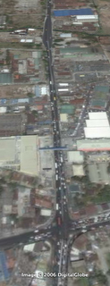
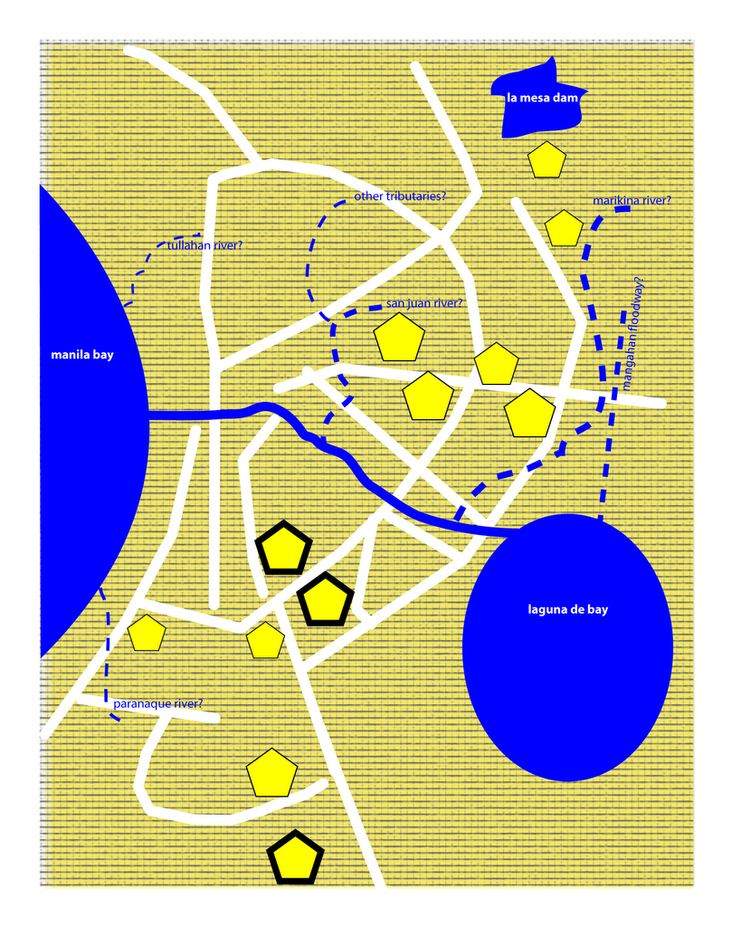
There are at least 5 roads in Metro Manila that I'd like to re-imagine and redesign, namely:

  1. Commonwealth Avenue (R-7)
  2. Quezon Avenue / Espana (R-7)
  3. Ortigas Avenue (R-5A)
  4. Sucat Road
  5. Alabang-Zapote Road
(Download the kml file via Google Earth Philippines. or view it on Google Maps.)

There is so much we can do to make them work and look better -make them more pedestrian and bike friendly -and they will contribute to the a more livable urban environment.

As wrote about rethinking our streets before, also here and here.

What can these streets be? I've cribbed the great images from the Livable Cities presentation of the American Institute of Architect's Center for Community by Design (Get the powerpoint presentation here 1,792 KB - and the PDF here 1,769 KB).

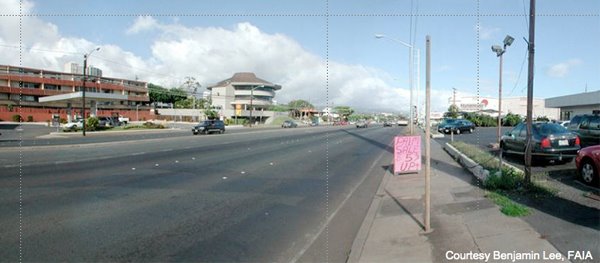
The pictures and text below are all from AIA. Click on the images for a larger version.

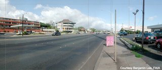
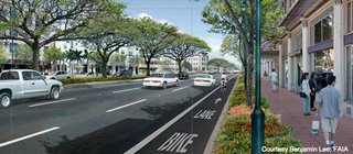
Here you have a typical strip commercial development. This image is from Hawaii but it could be Anywhere. This is clearly a car-oriented landscape with narrow sidewalks, a wide roadway and buildings set far back.
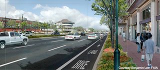
In this image, four key streetscape improvements have begun to change this to a pedestrian-oriented landscape.
  1. The sidewalks have been widened with landscape buffers to protect pedestrians from traffic;
  2. The buildings have been brought forward towards the sidewalk and retail has been added the first floors to create an interesting place for people to walk along;
  3. A bike lane has been added to the road to accommodate cyclists and provide another transportation choice;
  4. A median is included to reduce the perceived width of the road and facilitate pedestrian crossings.
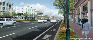
On the far side of the street, they’ve added mid-rise residential buildings with more retail on the ground floor. This mix of uses promotes neighborhood activity at all hours of the day.
By adding trees and landscaping, the street becomes a pleasant, shady place to stroll. Also notice another building in the background has been added. Infill development helps to preserve urban centers.
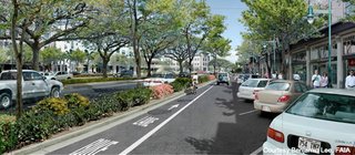
This image shows an alternative way to create a human-scaled street. Here, the bike lane is separated from thru-traffic and brought in with a local circulation lane for shoppers. The retail is still pedestrian-oriented and the angled parking serves a buffer from traffic.
I see no reason why we can't do this. And we can argue about the effects this will have on traffic.

For more images and like those above, visit Urban Advantage.

7.06.2006

going mental (3) -a river runs through it

Maynila was born on the banks of the Pasig -established by people who were taga-ilog ("river folk") and yet 600 years later, we are so disconnected from our bodies of water.

Notice my conceptual map - I know the Pasig connects the Bay to the Lake and I know it runs north of Makati and South of QC, San Juan and Mandaluyong - but I am, as I suppose the majority of us are, not aware of its eastward route. I have no mental image of how it meets the Laguna de Bay.

I have no mental image of the shores of the lake. I have a memory of driving around the lake -but not at the water's edge.

I know the San Juan River and Marikina River feed into the Pasig -but also have no mental image of where these rivers meet. I know the Manggahan floodway separates from the Marikina River at the Napindan Floodgates -and the floodway then runs straight towards the bay. I also know that the Tullahan feeds into the Bay and somewhere down south, the Paranaque River also feeds the Bay.

Why am I not aware of the paths of these rivers? Mainly because so few landmarks and public spaces are on the waterfront. Baywalk and the reclamation area face the bay. The Senate, the Cultural Center, the Folk Arts Theatre and the Coconut Palace are on the waterfront. So too the Quirino Grandstand in Rizal Park. The Malacanang is on the Pasig. The Jones, Macarthur, Quezon and the Ayala bridge over the river near Quiapo and Escolta.

Apart from that, very little of our urban life is connected to the water. So the rivers are dead -not just biologically, but also in our imaginations. The rivers do make their presences felt when they overflow their banks.

There are efforts to revive the Pasig and the return of the ferry will help -but until we reclaim the waterfront as public space, our waterbodies will live outside our conception of our metropolis.


(You can download a kmz file of the metro's major rivers on Google Earth Philippines or you can view it on Google Maps.)

7.05.2006

going mental (2)

Let's start with this. A conceptual map of Metro Manila. I've marked out the existing and potential business districts. Also the commercial centers. I've also put in the existing and proposed mass transit lines.

The symbology should be easy enough to understand.

It is by no means exhaustive (conceptual nga no!) but I will use it a starting point for discussing connectivity -paths and nodes within the metropolis.

Over the next few posts I will examine what is connected and what is not and what should be.

(Visit my latest post at Philippines Makeover to see some connections I'd like to make.)

(Email me if you want the illustrator file of the conceptual map.)

7.01.2006

going mental

They say if you want to understand something - you have to look at that something from a distance. That's why I am so excited about the high res images of Metro Manila and our other city centers in Google Earth. It's not so much the joy of virtual roof surfing but the chance to assemble a better mental image of our city. It is, as Roby Alampay puts it, the chance to connect visualization to action.

I spent my elementary years in a public school, took high school in the premier state university where I also earned my college degree. As good as my education was, I do not ever remember having seen or discussed a map of Metro Manila or any of its component cities during my matriculation.

(The only time I got to take a long hard look at the built fabric of our metropolis was in grad school -as I researched more into the history of the city.)

Why is that? I remember long discussions about national issues - history, sociology, culture -but I never once saw a map of the places I lived in.

I did not have a clear mental picture of the city which, for better or for worse, circumscribed my daily life.

I could navigate it pretty well. I lived in northern QC and worked in Makati and I could easily take the New Panaderos shortcut and cut through Don Antonio to shave 30 to 40 minutes off my daily commute. I could find a path from Intramuros to Reina Regente and Divisoria and then take a northbound route to Monumento. I could take airport road and go through the villages to get to Alabang - so I (as well as the rest of us) had a mental map of the nodes and paths and edges of the metropolis. I did not have a whole picture.

It may seem trivial -this lack of a whole picture - but it points to what Kevin Lynch calls the "imageability" of the city. I saw Metro Manila, as I suspect the general population does, only as disjointed nodes connected by circuitous paths.

Google Earth affords all of us a bird's eye-view - a more complete map of the city, and maps help us see not only distance -paths and nodes and edges -but also relationships and scale. Maps help us to see density -and open space. Maps help us to see layers of history, and economic segration and spatial inequalities. Maps helps us to see the whole picture.

There is a subversive element in seeing the whole picture. It leads us to ask why?

More importantly, it prompts us to ask "Why not?"

Quick Links

Notable posts on the metro