12.31.2006

your future is (still) ayala

(Full disclosure, I used to work for Ayala Corporation.)

The Makati CBD is the Philippine's undisputed premiere financial and business district and, despite the emergence of new CBDs, is still home to both the largest businesses and the tallest buildings in the country. That it became the epicenter of Philippine commerce is a testament to good planning, good corporate governance, and the long-term vision of the country's oldest business house.

The Ayalas invested in and developed the business district back in the 1930s, when Makati was just largely empty marshland and when the growing Manila metropolis was expanding to the north (Quezon City). Under the leadership of Joseph McMicking, the Ayalas masterplanned the 1,000+ hectares, intending it to become "Asia's showcase of urban development." (This was back when Singapore was still a trading post.) It was the first large scale, fully-integrated real estate project in South East Asia, the first to feature a business and commercial core surrounded by residential development.

Today, the CBD still hosts the most expensive office spaces and the priciest land values (save for Divisoria -which, per square meter, is still the most expensive land in the country) and has propelled its host city to the top of the LGU income rankings. (Makati has been dethroned from the top rank in the last few years by an ascendant and very well-managed Quezon City.)

Some half a million pinoys work in the CBD, their incomes directly supporting another 2.5 million of the population, and indirectly supporting probably 5 times that number as consumers and as producers in the economy. The CBD has shaped not only our country's economic history, but also the political and cultural history of the last five decades.

Ayala Land, Inc. (Ayala's real estate development arm) has more up its sleeve -with a land bank that will probably shape the next 50 if not 100 years of our history. There's the 254 hectares of Fort Bonifacio -with its new masterplan, then there's the 38 hectare UP North Science Park in Diliman.

The new crown jewel will be ALI's new developments in Canlubang*which, at nearly 17 square kilometers, is 1.5 times the size of Ayala's original developments in the Makati CBD. To put that in another perspective, you can fit 6.5 Fort Bonifacio-sized developments inside the Canlubang properties -with room to spare.

Canlubang, meanwhile represents just 41% of ALI's total land bank! That means, ladies and gentlemen, that your future urban lifestyle and experience will still be shaped, in no small part, by the 170 year-old company. Your children and your grandchildren will probably be working, living or shopping in some Ayala development another hundred years hence.

* -An aside: that last link is to bworldonline article which requires subscription, but Businessworld's online edition. But Businessworld, supposedly the leading business broadsheet in the country, STILL DOES NOT TAKE online payments via credit card -and asks would be international subcribers to instead FAX their credit card details to their offices in Manila. They even ask for the security number! How backward is that in this age of identity theft?? Is their sales division led by a luddite? Could someone please, please lead them to 21st century and to the internet economy?

12.28.2006

makati rezones


The city of Makati is revising its zoning code. Zoning, for the cities that use it, is the one legal instrument that pretty much defines the fabric of built environment -and so, defines the spaces and places we live and work in.

Makati's new zoning code -well, not new, really as it is a revised zoning code -changes some of the allowed uses and ups the floor area ratio* (thereby the building intensity, e.g. how tall or how massive buildings are) in various areas of the city. I think Makati uses a traditional Euclidean or Functional zoning, defining the allowed uses (commercial, residential, office, etc.) and using FAR (floor area ratio) to prescribe building heights and bulks.

I'm saying "I think" because I couldn't find a copy of either the new or old zoning ordinance online. (Note to all city goverments: PUT YOUR ZONING CODE ONLINE!!) I did find a pdf of a powerpoint presentation (pdf 1.9mb) given to the Makati City Council sometime August of 2006 that outlined the changes.

You can navigate/check out the zoning changes on the map on this page though it might be be use the larger map as for some reason, not all my placemarkers are showing on the map on this page. The map has no street names, so you can cross reference the streets (at least for the CBD) using this flash map. If you have GoogleEarth, you can download the overlay image here (kmz 855kb file).

Over the next 5-10 years, expect to see the following changes:

  1. Convenience retail (small stores, ala 7-11) on the ground floor of the buildings along Ayala Ave. before Makati ave. and along Makati Ave. towards Paseo de Roxas.
  2. In Legaspi and Salcedo Villages, new residential towers will rise along Dela Rosa, on the backside of the office buildings along Ayala Ave. and along Valero St. (The lots there are mostly occupied by structured and surface parking. Also expect a 25% increase in building heights as they raised the FAR from 6 to 8.)
  3. We'll see more intense development (taller buildings) on the north side of Sen. Gil Puyat (Buendia) from EDSA to Ayala Ave. (the Bel-Air/Jupiter St. side).
  4. More intense commercial development is allowed between Yakal and Malugay Sts. (north of Buendia)
  5. Expect buildings to double their size/height along Pasong Tamo (on both sides of EDSA)
  6. And also more intense commercial development on Pasong Tamo before Dela Rosa
  7. Ditto for (more intense) commercial development along the western side SLEX between Zobel Roxas and Cash & Carry.
  8. More intensive neighborhood scale commercial along Zobel Roxas before SLEX
  9. Expect 30% taller buildings along both sides of the stretch of EDSA between Guadalupe and Estrella.
The new code also anticipates the changes in the Fort Bonifacio masterplan and greenlights the redevelopment of the old Colgate-Palmolive and SC Johnson compounds and the Metro Club into high-rise residential, office and commercial spaces. The two properties across Estrella st. from Rockwell is part of the development's expansion plan. (Looks like they will be building more residential towers and maybe some BPO office space.)

There were a few bulletpoints about "innovations" in the pdf that got me piqued, namely (my notes in italics):
  • Granting of density bonuses (bonus in exchange for what?)
  • TOD (Transit oriented development!! Where?)
  • Green spaces (public spaces, I hope! and maybe in exchange for density bonuses.)
  • Land readjustment scheme (as a way to reshape the small irregular lots in the older, low-rise, dense areas of the city)
  • Heritage zone (I guess for the old poblacion)
  • TDR (Transfer of Development Rights!!)
I'd love to see more details about this list.

Makati's new code also calls for the creation of the Office of the Zoning Administrator -which could mean more transparency and better enforcement or more bureaucracy.

I know Makati isn't alone in revising its zoning ordinance. Manila is doing it too (and I'm waiting for a friend to send me a copy of Manila's new code. Word is, they are removing heavy industrial zones and bringing in Planned Unit Development. - My comments on that new code, once I review it.)

The new zoning codes are testament to the continuing growth and change in our megacity and, hopefully, opportunities to improve our cities.

Interactive map via MapLib.Net
Here's a graphic that better explains how FAR and lot coverage define building heights and bulks.

12.26.2006

THANK YOU FUNDABLE!!!

Thank you, thank you, thank you fundable.org!!!

They forwarded the pledges we collected even if we didn't hit the target!

Merry Christmas, Jack!

Thank you to everyone who pledged! (and may I add #46. Adi A. who pledged with 20 minutes left to go.)

Thank you to Wily Priles, Amalah and Vickie for posting about Jack. And to Raymond V., Aimee A. and Mai T. for spreading the word.

Tiny Tim puts it best, "God bless us, everyone!"

visualizing density

After reading this article from Fortune (forwarded by Sol), I worked out a 3d chart using wikipedia data comparing the relative land areas and population densities of a few megacities.

The chart represents land area in square kilometers along the x,y axis (width and depth), and population density in people per square kilometer along the z axis (height).

The tall red column represents Metro Manila's density and area vs. other megacities. We're nearly three times the density of Hongkong occupying little more than half HK's land area. Even Mumbai distributes its density a little better.

the truth about google earth


Found this YouTube video via urban cartography.

Now, if I could only pick up those damned billboards with my cursor...

12.24.2006

1 day and more than $2K to go

With little more than a day and still $2,025 short, it looks like we won't hit our $5,000 target for Jack's fundable campaign. The rules are, if we don't hit the target, fundable will not collect any of the pledges.

(Read about Jack here. And here.)

It is a big disappointment for us -and we feel we've let Jack down. We tried our best and we asked as many people as we could.

Thank you so much to the following dear friends who did pledge:

  1. Abby C.
  2. Aimee A.
  3. Alex And Alexis S.B.
  4. Alice M.
  5. Amanda S.
  6. Amy S.
  7. Anna A.
  8. Baly C.
  9. Beatriz L.
  10. Candice C.
  11. Catherine L.
  12. Claire S.
  13. Daniel M.
  14. Elaine D.
  15. Elaine M.
  16. Elizabeth H.
  17. Ellen T.
  18. Eric And Daisy Dlp.
  19. Essa R.
  20. Frederik F.
  21. Georgia B.
  22. Isabel F.
  23. Ivy A.
  24. Jennifer H.
  25. Jennifer S.
  26. Jenny C.
  27. Jonathan L.
  28. Joselito A.
  29. Leah K.
  30. Lia U.
  31. Lola R.
  32. Mai T.
  33. Malyn K.
  34. Margaret M.
  35. Maria Cecilia T.
  36. Martin H.
  37. Michelle G.
  38. Michelle M.
  39. Paul E.
  40. Rajendra S.
  41. Raymond V.
  42. Reine P.
  43. Stacie T.
  44. Therese L.
  45. Yael A.
Maybe's 24 hours is still enough time for a miracle.

Even then, all is not lost. If we don't hit the target, then will ask our friends to send their check directly to Jack's grandmother:
Rita S. Simbulan
548 S. Normandie Ave., Apt. 1, Los Angeles, CA 90020
Office - (213) 747-5588 Ext. 233 - 9 a.m. to 5:30 p.m., Pacific Time
Cellphone (213) 447-3587
Email: emerald5172 at yahoo.com
Office Email: rita at veniceinvestments.com
We'll keep praying -and we hope you say a prayer or two for Jack and his parents, and all the other children and families suffering through faconi anemia. May they find joy this season through and despite the struggle.

Merry Christmas.

12.23.2006

landcraft!

Very very addictive! Specially for mapgeeks.

Generate your own landscapes, ala SimCity's God Mode.

Try it here.


(nothing follows)

12.22.2006

the greening of seoul

The Guardian Weekly reports on the Seoul's demolition of a major highway and the restoration of a river and a park in its place:

"The demolition of a vast motorway through the centre of South Korea's capital and the restoration of a river and park in its place proves that mega-cities can be changed for the better. One year ago this month, several million people headed to a park in the centre of Seoul, the capital of South Korea and seventh-largest city in the world. They didn't go for a rock festival, a football match or a political gathering, but mostly to just marvel at the surroundings, to get some fresh air and to paddle in the river."

...in a revolutionary act of ecological restoration that is now being examined around the world, the city of Seoul, under the leadership of the then mayor, Lee Myung Bak, pledged in 2002 to restore the river, tear down the motorway and create a 8km-long, 800-metre wide, 400ha lateral park snaking through the city where the river once ran."
Here's the clincher: tearing down the motorway did NOT result in the traffic nightmare the naysayers were predicting:
"We discovered it was a case of 'Braess paradox', which says that by taking away space in an urban area you can actually increase the flow of traffic, and, by implication, by adding extra capacity to a road network you can reduce overall performance." (emphasis mine -urbano)

[Kee Yeon Hwang, a professor in the department of urban planning and design at Hongik University -and the principal author of the masterplan] said: "The tearing down of the motorway has had both intended and unexpected effects. As soon as we destroyed the road, the cars just disappeared. A lot of people just gave up their cars. Others found a different way of driving."
Which should be something Metro Manila's traffic planners should think about everytime they decide that the best way to solve the traffic mess is to widen the roads and build more flyovers. (Read more about Braes and the Road Network Paradox.)

The other gem was the impact on the environment -apart from just the river restoration:
"We found that surface temperatures in summer along the restored river were an average 3.6C lower than 400 metres away. The river is now a natural air-conditioner, cooling the capital during its long hot summers. Average wind speeds in June this year were 50% higher than the same period last year.”
Says Treehugger:
"Citizens flock to the water's edge--there are waterfalls, play spaces, running tracks and sitting areas. Birds, fish, plants and a variety of wildlife have also returned and increased. Shanghai and Los Angeles are looking at the results because Cheonggyecheon Park has become a model for other large cities seeking to link regeneration and environmental progress."

It also should inspire us to consider daylighting some of the esteros that we have paved over, and seriously pursuing the restoration of the Pasig. It should, like Cheonggyecheon Park, serve as the major public amenity for our metropolis.

Here's the link to the full article and the post on Treehugger.

12.17.2006

quirino walkable district:
opportunity sites

(Cross posted on Philippines Makeover.)

Next on our urban sketch project, let's look at the opportunities for redevelopment in our proposed walkable district. (You can catch up with parts 1 and 2 of this series.)

Focusing on the middle path -right down Quirino Avenue -we find more than 8.5 hectares right along the corridor that would be ripe for redevelopment. (Click on the picture for a larger image outlining the sites, check out the opportunity sites on Google Maps or download kml file (2.1kb).)

Also, just to give you context about the opportunity available, here are scale comparisons of the site vs. Glorietta and vs. Megamall (thumbnails after the jump).

The eleven opportunity sites are a combination of national and local government owned land and underutilized, privately owned lots. The redevelopment of the area then requires government incentives and public-private partnerships.

The largest chunks, thankfully, are in government control. The properties are also located at very strategic portions of the path. They include the two Bureau of Plant Industry (BPI) lots, the Leveriza (Manila) Children's Park and a segment of the Manila Zoo.

The two BPI lots make up about 3.3 hectares. If zoned for an FAR* of 2.5, the lots could deliver as much 890,000 sq.ft. (82,500+ sqm.) of development to the market. The lots are ideal for transit oriented development (mixed-use, with retail on the ground floor, office spaces and three to five residential towers) - taking strategic advantage of the Quirino LRT station -and catering to Makati workers, with the CBD just 7 stops (4 on LRT-1 and 3 on the MRT) and one transfer away. The residential component (condo and apartments) could also service the housing demand from students from DLSU and the other schools nearby.

The national government (BPI is under the Department of Agriculture) would do better to relocate the Bureau to where it could better serve its agricultural clientele -or where it could be closer to other agri research centers (like Los Banos). They could also require exactions from the sale, say by requiring that a percentage of the residential units be set aside for subsidized housing for public school teachers.

Meanwhile, the Manila Zoo could raise much needed funds by leasing off part of its property along Quirino. They could give up about 100 feet deep of the zoo's layout and bring about 12,000 square meters to market. (This project might already by under contemplation by the Friends of Manila Zoo Foundation, as I found a 1997 EMB circular (pdf) listing an ECC for a Manila Zoo Redevelopment Project under a company called "Zoo Village Redevelopment Corp.") This would allow the zoo to raise funds and they can also elevate the zoo's civic presence by requiring the leasee to build a structural entrance to the zoo. (Which would be way better than just the current metal sign.) The lease can also provide structured parking for the zoo.

The zoo's location at the bend of Quirino makes it ripe for a more visible structural entrance that would serve as a terminating vista, calling strollers from the corner of Qurino and Taft to walk down to the bend and the zoo entrance. The new entrance would neatly bisect our proposed pedestrian path -and serve as a waypoint from the LRT station to the bay and the baywalk.

Manila City could also raise funds and improve the services of the children's park by leasing off the property but requiring the lessee to set off the majority of the lot for a much improved children's park. The lessee can also be required to maintain the park freeing the city of the maintenance costs.

Likewise, Ospital ng Maynila could raise operational funds by leasing off its Quirino edge and its parking lot fronting the bay. They could require the lessee to provide structured parking for the hospital.

The rest of the opportunity sites are probably privately held properties and include a large empty lot (since the Google Earth image is at least a year old, the propery may not be vacant anymore), a motel, a possible defunct water storage facility and two large underutilized properties that currently house a gas station and some nominal office spaces.

The city government could provide incentives for redevelopment of these particular properties.

Here's a rundown of the sites.

Site
est. area (m2)
1. Bureau of Plant Industry 20,000
2. Bureau of Plant Industry 2 13,000
3. Empty lot 2,800
4. Manila Children's Park 12,500
5. Manila Zoo Edge 12,000
6. Motel 4,600
7. Ospital ng Maynila Edge 2,750
8. Ospital ng Maynila Parking Lot 3,800
9. Underutilized property 1 6,500
10. Underutilized property 2 4,800
11. Water storage facility (?) 2,100


Images on the left: the area compared to Glorietta (top) and Megamall (bottom). Click for larger versions.

What's missing:

If this were a full urban planning study, we would do well if we had:
  1. the zoning map for the area
  2. a property list along with a cadastral or tax assesment map
  3. current pictures of the existing buildings on the sites
Next up: Streetscape and a massing and volume study.

*Floor Area Ratio (also called Floor Space Index) = (Total covered area on all floors of all buildings on a certain plot) / (Area of the plot)

12.13.2006

steven johnson on
the challenge of the megacities

Steven Johnson (of "Emergence" -one of my favorite books on understanding cities) continues his Urban Planet blog for the New York Times with a look at the challenges of today's megacities --comparing them to the challenges of victorian age London (which he documents in his new book "The Ghost Map").

He cites Robert Neurwith's "Shadow Cities" -and rings a bell of hope for today's urban agglomerations -and pretty much echoes my own reasons for feeling positive about Metro Manila.

If London could transform itself so dramatically in a matter of decades, there’s at least reason to hope that the megacities of the developing world can do the same. They have populations 10 times the size of Victorian London’s, but they have one crucial advantage: most of the problems they face we already know how to solve. The Victorians had to invent a whole set of institutions — and learn from a long list of scientific breakthroughs — in order to make large-scale metropolitan living into a sustainable practice. But now we know how to prevent cholera; we know how to build sewer systems and water-treatment plants; and we can identify and track emerging diseases with an accuracy that would have astonished the scientists of the 19th century.
Read the rest of Johnson's article via NYT here (subscription). - Whole article after the jump.

December 12, 2006, 10:28 pm
The Challenge of the Megacities
By Steven Johnson

I began these posts with a look back at the squalor and terror of London 150 years ago, a city literally drowning in its own filth, ravaged by disease, and haunted by a scavenger class living off the refuse of the city — a group so large in number that had they broken off and formed their own city, it would have been the fifth largest in England. My trip to London last week brought yet another reminder of the immense progress the city — like most other cities in the developed world — has made in a relatively short time. The air and water are far cleaner; the killer epidemics of the Victorian age have been vanquished; life expectancies have doubled; and overall standards of living are significantly higher than they were in the 1850s.

But something else has changed since then. London was the largest city on the planet back in 1854, but now it is on the smaller side, as world cities go. (It ranks in the mid-teens, depending on how you define its borders.) Many of the cities that now top the charts — Mexico City, Sao Paulo, Mumbai — have as much in common with Victorian London as they do with the modern version. London’s hundred thousand scavengers are a mere footnote compared to the massive shantytowns that have exploded at the margins of today’s megacities.

These squatter communities have been built on land that is, technically speaking, illegally occupied — without official title deeds, electricity, running water or waste removal systems. (Underground economies providing all these services have started to develop, however.) In such places, the waterborne diseases — including cholera — that plagued the Victorians are still rampant, thanks to miserable public health and sanitation resources.

The squatters worldwide now add up to a billion people, and some experts project that by 2030, a quarter of the world’s population will live in shantytowns. This is not entirely reason for despair. As the writer Robert Neuwirth argues in his extraordinary book “Shadow Cities,” shantytowns are places of dynamic economic innovation and creativity. Some of the oldest ones — the Rocinha area in Rio de Janeiro, Squatter Colony in Mumbai — have already matured into fully-functioning urban areas with most of the comforts we’ve come to expect in the developed world. Improvised wood shacks have given way to steel and concrete, electricity, running water, even cable television.

If London could transform itself so dramatically in a matter of decades, there’s at least reason to hope that the megacities of the developing world can do the same. They have populations 10 times the size of Victorian London’s, but they have one crucial advantage: most of the problems they face we already know how to solve. The Victorians had to invent a whole set of institutions — and learn from a long list of scientific breakthroughs — in order to make large-scale metropolitan living into a sustainable practice. But now we know how to prevent cholera; we know how to build sewer systems and water-treatment plants; and we can identify and track emerging diseases with an accuracy that would have astonished the scientists of the 19th century.

This is reason for both hope and for shame. Cholera itself is so easily treatable that, in controlled laboratory experiments the United States, test subjects can be safely infected with the bacterium. And yet water-related diseases including cholera still kill up to 5 million people a year worldwide, many of them in squatter communities. The hope lies in the fact that we know how to stop these deaths. The shame is that we haven’t actually managed to do it yet.


Image credit: S. Johnson in London, via stevenberlinjohnson.com

12.09.2006

quirino walkable district:
nodes and paths

(This entry cross posted at the Philippines Makeover Blog.)

Getting back to our urban planning sketch (part 1 here), one way to think about walkable districts is to think of nodes and paths. (This is pretty much a Kevin Lynch approach.)

Nodes are centers of activity - paths are...well, paths that connect the nodes. Nodes also tend to define the area around the node -turning the area into a "district" of sorts. Nodes can center around a single significant building or can be formed by a cluster of activities.

Paths of the other hand, have the power to define the edges of districts.

I've picked out the key nodes in our project area and the paths that connect them. It's important to think of nodes when planning walkable districts as the nodes serve as destinations and define the types of activities in the walkable district. The nodes also define the character of the paths - who uses the paths and what time of the day the path will be most used.

So our project area (which I am defining as the area loosely bound by the two transport nodes of the Quirino and the Vito Cruz LRT stations - and then the area west from the stations to the Bay), has several clusters of nodes -with different activities. (Click on the picture for a larger image or download the highres version here (png 3.3Mb) or download the kmz (164kb) file -with image overlay -here.)

The nodes and their surrounding activities include:

  1. The north cluster with:

    The Malate Church -with its public park foreground -and the park bordered by all day restaurants
    Remedios Circle -which is actually a barely used public park -also surrounded by restaurants -most of whom provide active nightlife to the area (UPDATE: Citizen of the World has great pics of the new Remedios Circle, and he links to Bong Austero's musings on the redesigned park), and
    the San Andres Public Market

  2. A middle cluster defined by:

    The Manila Zoo, and
    The Leveriza Children's Park (formerly Paraiso ng Batang Maynila)

  3. A south cluster with:

    The Rizal Memorial Sports Center - which also serves as a concert venue apart from sports center
    Harrison Plaza (a shopping center)

  4. Several other important destinations at the very edge of the district:

    The Metropolitan Museum
    The Manila Yatch Club
    The Cultural Center of the Philippines complex (including the FAT and the PICC)

Another major destination is, of course, the Bay itself.

Three possible pedestrian corridors (green lines) serve these clusters.
  1. A northern path from Quirino Station to Malate Church via San Andres Road (with a branch that turns north to Remedios Circle)
  2. A middle path from Quirino Station to the Bay right past the Zoo and the Children's Park (along Quirino Avenue)
  3. A southern path from the Vito Cruz Station -right up Vito Cruz St. to the CCP complex.
There are two other signficant pedestrian corridors:
  • M. Adriatico St. between Vito Cruz and Quirino (connecting Rizal Memorial and Harrison Plaza to the Zoo and the Park)
  • Roxas Boulevard (does Baywalk stretch all the way to here?) at the western edge of the district
I've color-coded the nodes -green for parks, blue for cultural (including sports), and red for commercial.

There are other ways to classify the nodes that will help us think about the activity patterns. The zoo and the park are daytime activities -while CCP, FAT and the Sport Center serve daytime activities with surge activities (major concerts and sports events) in the evening and on weekends.)

Ideally we should also have the numbers on how many people go to these nodes (both during regular hours and during surge events).

The activities, the hours, the number of people will tell us what other facilities we need in the area if we are to serve a pedestrian audience.

It's also important to consider major traffic thoroughfares (in gray) bisecting the study area, which in our case (and by order of traffic volume) are:
  • Roxas Boulevard
  • Taft Avenue
  • M. Adriatico
  • F.B. Harrison
Although Quirino (east-west) does carry some load, significant traffic flows mainly along the these north-south arterials.

(Next up, Opportunity Sites.)

12.07.2006

14 days and 4,100 to go

After seven days, the Save Jack Simbulan fundable.org campaign has hit the $900 mark, just a hundred shy of 20%. We have 14 days left to complete the target and need 164 more people to pledge at least $25 each. Remember that if we DON'T hit the target amount ($5,000) in pledges, then no money will be collected.

Our sincerest thanks to the following: Georgia, Jenny, Aimee, Mai, Therese, Candice and Tim*, Malyn, Mel and Paul, Joselito*, Essa and Frederik, Rajendra, Cecille*, Reine and Andrea, Michelle, Alice, Cathy and Manuel, Anna, Amanda, and Elizabeth and Ryan. Special thanks to Mai and Aimee and Raymond V. who helped to spread the word. Also special thanks to Amalah, for posting about Jack.

If would like to help out, the fund takes pledges via paypal or credit card. You could also help out by either posting a link to this post, or Jack's blog or sending email to your friends about Jack. You could also choose to help Jack through the fundraising campaign led by Babette's (Jack's mom) friends the Ateneo Student Catholic Action (AtSCA Batch 94, Cell 3 and Cell 6). Details via the savejacksimbulan.org website.

And for the doubters, I am reproducing my wife's blog post from a few days ago (after the jump).

If you would like to confirm Jack with a real live person, contact Jack's grandmother (in the US) or his parents (in the Philippines).

(BTW, i know there are a lot of good causes apart from Jack. Please also help Naga City recover from Typhoon Reming.)

(*-joselito, candice, cecille -fundable.org lists double pledges from each of you, did you mean to pledge twice or did you accidentally click twice? Please email me at urbanodelacruz_at_gmail_dot_com if it was an error and I can delete the redundant pledge.)

Jack and Fanconi Anemia 101


As mentioned in the last post, I realized that a lot of folks might be unable to go through Jack's whole blog and other sites that explain his disease, Fanconi Anemia, so I'm going to do my best to distill what I know about Jack and FA.

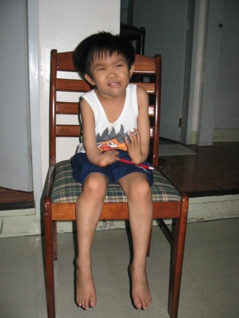
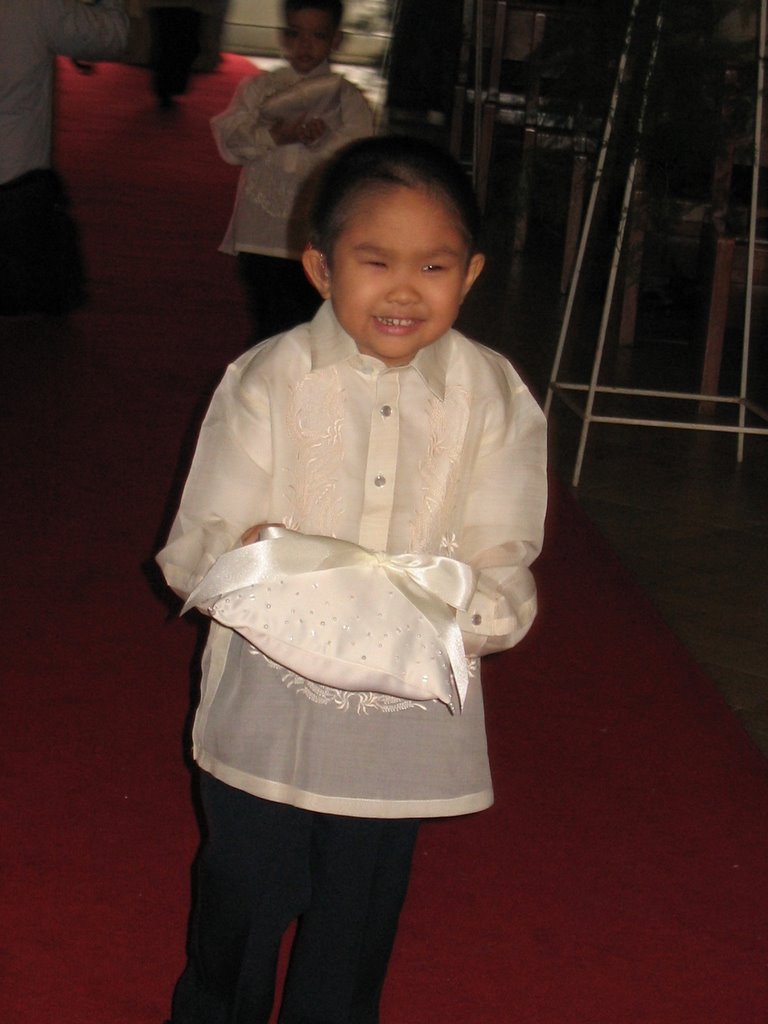
First of all, Jack really and truly does exist. Benjie worked with his mom, Babette, back in Manila from '97 to '99. We attended her wedding to Juni. (I feel I have to write this just in case some readers have been victimized too often by internet scams.)

Secondly, Jack really and truly does have Fanconi Anemia. It's an inherited disease--sort of like hemophilia in pattern (a child of two parents with mutations in the same genes for FA has a 25% chance of being born with the condition). It's a disease that can and usually does lead to leukemia, and older patients tend to have a very high (relative to the general population) rate of carcinomas in the head, neck, gastrointestinal and gynecological areas.

Third, Jack's been diagnosed with first-stage bone marrow failure--his bone marrow is starting to fail at its job which is to produce enough red blood cells(to carry oxygen), white blood cells (to fight infection) and platelets (to help the blood clot). Hence, the need for Babette & Juni to constantly monitor Jack for symptoms indicating a low count of any of these cells, many more blood tests on Jack than you'd need in a healthy lifetime, and transfusions when any counts are low.

Jack needs a bone marrow transplant.

Jack has been subjected to many blood transfusions already this year, and I can only imagine how painful it is for him and his parents every time he needs one, and how each day they wake up hoping that Jack won't need another trip to the hospital. If you read his blog, though, you'll maybe laugh (as I do) when I read about Jack's jokes, wisecracks, and arguments--this boy is spirited, intelligent, funny, so full of character.

(There are risks to the bone-marrow transplant too, but right now it's their best hope. Jack can't just keep getting transfusions indefinitely every time his platelets go down--he increases his risk for infection and for rejecting the transplant later on.)

Fourth, Jack needs to have his bone marrow transplant elsewhere.

The hospitals back in the Philippines don't have the capacity to deal with the procedure. Juni and Babette have been told that their best bets are hospitals in Cincinatti and Manhattan in the US. For this, they have to raise a LOT of money.

(On the bright side, there are three potential matches in the US national bone marrow registry!)

Fifth, Jack needs $350,000.

Juni and Babette, by Filipino standards, are well-off. They are both college-educated, have white collar jobs, own their own home (though still paying the mortgage). In contrast, most Filipinos struggle to put meals on the table, can't afford the down payment for their own homes, consider a visit to McDonald's a luxury.

But there's no way Babette & Juni can produce $350,000 on their own to pay for Jack's bone marrow transplant. (That's the cost of the procedure alone, not including flights, accommodations, meals, etc.) They can probably save and borrow to cover the latter costs, but they need all the help they can get to raise the $350,000 for the transplant. (Most Filipinos will not earn the equivalent of $350,000 in their lifetimes.)

(Health insurance barely exists back in the Philippines. Babette and Juni get some through work but what they have doesn't cover their current medical expenses like transfusions and tests, much less a procedure like the BMT.)

We are all hopeful that help will come in other ways--one of Amalah's readers pointed out St. Jude's in Tennessee, which at this point I'm very hopeful about. But until and unless Babette and Juni hear for sure that St. Jude's or a similar facility can arrange the procedure at little or no cost, we have to proceed as if we have to raise the entire $350,000 ourselves.

Sixth, Jack needs your help. NOW.

Prayers are good. (I believe in the power of prayer--to heal those who are sick AND to sustain those caring for the sick.)

Donations to Jack's fundable account are great (it runs till Christmas day!).

If you feel you can't make a donation, I respect that. I understand people have different priorities, and their own crises to worry over. But do think about it. If you can't donate, maybe you send family and friends toward this blog, or Jack's? Or the fund?

Lastly, and I hate to "play" this card: but try to put yourself in Juni & Babette's shoes.

Imagine having a child with a serious, life-threatening disease that's mostly unheard of where you live.

Imagine not having health insurance, and living in a country that's medically a few steps behind the first world when it comes to rare cases like FA.

Imagine how unreachable $350,000 seems when you earn maybe $25000 or $30000 a year before taxes.

Imagine getting up every day hoping your child will get through it without getting sick or needing a transfusion.

Thanks for reading. Peace and blessings to you!

12.02.2006

the city of the future

The History Channel is holding a competition called "The City of the Future: A Design and Engineering Challenge."

From the competition website:

The civilizations covered in Engineering an Empire on The History Channel achieved the impossible—they were the first to design and engineer marvels that astonished the world and transcended time. The History Channel, with its sponsors Infiniti and IBM, are challenging today's top designers, architects and engineers to do the same in The City of the Future: A Design and Engineering Challenge.

These competitions—hosted in New York City, Chicago and Los Angeles—challenge teams to produce a vision of their city 100 years from now that, like the engineering and architectural marvels of past civilizations, has the staying power to endure for centuries to come.

The winning City of the Future designs from New York, Chicago and Los Angeles will continue on to the national online competition where you, the viewer, will decide who will be named the national grand prize winner! Starting January 2, design-legend and chief juror Daniel Libeskind will lead the consumer vote.


Here's the description of the winning entry from Chicago (via WorldChanging).
The winning entry, however, was absolutely deserving of the top honor. UrbanLab, headed up by, Martin Felsen and Sarah Dunn, envisioned a future where water is the most valuable natural resource. In UrbanLab's world, Chicago will become a key exporter of water to regions around the country, and as such the city's entire economy must shift toward the retention and distribution of water. Entitled "Growing Water," the design team presented a Chicago of the future where all east-west boulevards have been returned to greenspace. Vast swathes of native grasses and hardy trees will replace familiar routes like Grand Avenue and Diversey Parkway. A clean, efficient, elevated monorail system will eliminate the need for street-level travel.

These strips of grass and shrubbery, then, would serve to capture precipitation, biologically filter it and funnel the clean water into the Chicago River, which would then replenish Lake Michigan. UrbanLab's concept is designed to allow for 100% of Chicago's water to be recaptured for use or export. Of course, the design requires the flow of the Chicago River to be returned to it's original pre-20th-century route flowing into the lake.
Anyone care to sponsor a design competition on Metro Manila in the 22nd century?


11.30.2006

jack

Help us save Jack

We're helping to raise money for Jack Simbulan, a five year old boy who desperately needs a bone marrow transplant to fight Fanconi Anemia.

We figure we can find at least 200 friends willing to pledge $25 or more to raise $5,000. (This is just a fraction of the $350,000 they need to pay for the operation.)

A pledge of just $25 (or more)

We're using fundable.org to raise the $5K -and are asking for pledges. You can pledge $25 or more via paypal or credit card. You will NOT be charged for your pledge until the total amount of pledges reaches the target amount.

Just 25 days

We have 25 days to raise the amount. When we reach the target amount fundable.org will send a check to Jack's grandmother in California.

MAKE THE PLEDGE HERE

Please spread the word

We think this is a very worthy cause -and we hope you can help us help Jack. Could you also help us by linking to this post or to jack's fundable site or emailing this post to your friends.


You would, too.

We know that if we were in Jack's parent's shoes, we would try anything and everything to help our child. We hope you feel the same way, too.

On behalf of Jack and his parents, thank you.

Benjie, Vickie and Teo

11.29.2006

creating the quirino walkable district:
an urban planning sketch

(cross posted to Philippines Makeover)

Roby's original intent with the Philippines Makeover blog was to inspire people to use Google Earth and SketchUp to reimagine our cities. I am finally indulging him (and myself) with a sketch study on creating a walkable district using Quirino LRT station as the epicenter -with Quirino Avenue as the axis and the southern Malate district as the study area. I'd like to explore how we can improve this part of the city by making it more walkable -and hopefully, more livable.

Click on the image to the right to see a larger view of the study area. You can also see the area and the markers on Google Maps. If you prefer, you can download the kmz file for viewing on Google Earth.

Why the Quirino Station? I don't know. It seemed as good a choice as any but what appealed to me was its proximity to several urban amenities (the zoo, the bay, the sports center, remedios circle, leveriza children's park, etc.). The stretch of Quirino between Taft Avenue and Roxas Boulevard also presents some very interesting opportunity sites.

I am doing this urban planning sketch...

  1. as a thought experiment, to see what possibilities there are
  2. as a model/instigation to hopefully jumpstart other flights of imagination
  3. as a showcase of physical urban planning -to show what comes into play and into consideration when you plan an area (i.e. -the physical designs, the policy approaches and the community consensus building)
A blogpost is a limited medium when it comes to illustration so I will try to create a pdf version of each post complete with maps and diagrams.

So we start with the walking shed. A normal, healthy person can comfortably cover 1/4 of a mile during a 5 minute walk and 1/2 a mile during 10 minute walk. (The number is awkward when translated into kilometers -but if you want the figures: 5 minutes = 0.402336 km or 400+ meters; 10 minutes = 804672 km or 800+ meters.) That radius has been the basis for the design of neighborhoods since Clarence Stein and Henry Wright proposed the plan for Radburn, New Jersey. (If the Radburn plan looks familiar to you, whip out your Google Earth and navigate to Philamlife Subdivision. Philam as well as most of the QC Projects were patterned after the Radburn/Garden Cities template.)

The following landmarks are within a 10 minute walk radius of the Quirino LRT Station:
  • The bars in malate
  • The Remedios Circle
  • The San Andres Market
  • Malate Church
  • The Manila Zoo
  • The Leveriza Children's Park
  • Ospital ng Maynila
  • Harrison Plaza
  • The Rizal Sports Complex
  • DLSU, Benilde, St. Scho and PCU
and just a little further off:
  • The MET
  • Bangko Sentral
  • The Manila Yacht Club
  • The Army-Navy Club
  • UP Manila
  • PGH
  • NBI
  • The Supreme Court
  • Robinson's Malate
So you see, the walkshed has a lot of promise.

I'd like to fill up this map with as much data as I can and gather as many landmarks as I can place within the walkshed, so if you have the time and GoogleEarth skills, churn out markers on places / landmarks (restaurants, shops, offices, etc.) within the walkshed and send us the kmz files.

Digital copies of barangay maps of this district would also be very helpful.

Next up: opportunity sites within the walkshed.

design of democracy (6)
signal, noise and oligopsonies


At last. This took a while. I struggled with parsing the design ideas but realized that I needed to talk about the system in more theoretical terms (i.e. -signal processing and economics). I struggled with making the concept as succinct and reachable as possible but decided I didn't want to sound condescending nor do I want to patronize my readers (assuming I still have readers). I hope you take this (more esoteric) post in the context of the rest of the series (1, 2, 3, 4 and 5).

In my last post on this topic, I discussed how large electorates basically cause a market failure in the eoconomic-transaction model of democratic elections. The information asymmetry inherent in reaching a large electorate causes a market failure by reversing the transactional role of the candidate and the voter. The candidate becomes the buyer in the equation, the voter is the supplier. The kink in the system is that the buyer buys only in bulk -and the power shifts to the aggregators (middlemen) who can deliver or assemble the required number of votes. (The role of the aggregator can take the relatively "benign" form of the spinmeisters and message shapers or the media. It can also take the more malignant incarnation of the dagdag-bawas comelec mafias.)

The small number of bulk buyers (candidates) relative to the large number of suppliers (voters) characterizes an oligopsony.

The information asymmetry in the system is basically a signal vs. noise problem. The large electorate prevents direct one-to-one communication (symmetrical communication) between candidate and voter. To reach as large an audience as possible (to sway as many voters), the candidate's message must be amplified through various channels. Inherent in any amplification is distortion, noise and filtering. The fidelity of the signal is further compromised by the adversarial nature of elections. Attack ads, dis- and mis- information campaigns increase the noise in the system apart from the cacophony of multiple messages from multiple sources. Again, both the candidate and the voter (moreso the voter) cede power and control of the communication (and subsequent transaction) to the media channels.

(Some may argue that new media (the internet) may correct some of that information asymmetry. The Net does undercut the role of traditional media but current technology only really adds to the noise, requiring even more work for the voter to extract signal from noise.)

How we solve the problem? Well, how does one solve a) oligopsonies and how does one b) reduce noise in the system?

oligopsonies
  1. You can try to regulate an oligopsony so as to cut the power of the buyers and aggregators.
  2. Or you can act break up the market. In an oligopsony, the suppliers (voters) have less power because very large majorities (or pluralities) are required to win elections. (Each vote is further diluted by the number of posts a voter must fill up on the ballot.) Breaking the market almost always means atomizing the market. Breaking it up into smaller pieces so there are smaller markets with less candidates vying for the vote of a smaller electorates. (And no, this is not an argument for federalism. I am talking about the size of the markets, not the form of the governance.)
We've tried the first option -regulation -as evinced by the myriad rules governing our electoral campaigns. Regulation requires enforcement and apart from our weak enforcement, it is also true (I think I've said before) that any system that requires external enforcement to work is essentially an ineffectively designed system.

signal-to-noise
  1. You can reduce the noise in the system by increasing the signal and reducing the noise in the signal-to-noise ratio. You can try to do that by brute (technical) force by designing a system that checks for fidelity and corrects for deviations from the signal at multiple points. Systems that do this require more energy and more complexity. (The more complex a system, the higher the potential for failure.) Also, the stronger the amplification (i.e. -media to reach 50M voters) the more energy you need to ensure the fidelity of the signal.
  2. You can also spend energy to make a more sophisticated receptor that can internally filter noise from the signal.
  3. Or, you can cut the distance between the signal emitter and the receptor, reducing the need for amplification and lowering the incidence of noise.
Again, in this case, we've tried the first two options - hoping independent media can insure the fidelity of the signal - or educating voters hoping to turn them into more sophisticated receptors.

What we haven't tried to do is option 2 in both cases: breaking up the market and cutting the distance between the emitter and receptor.

And this is where I make the case for smaller electorates - and ultimately the design proposal. That's up next in what is hopefully the last installment of this series.

11.20.2006

bad idea


One of the last episodes on MLQ III's The Explainer's was on Capital Planning (with Paulo Alcazaren). I don't get ANC where I live so I cannot judge the contents of the show -I can only go by the shownotes that MLQ III posted on the-explainer.com. I think Mr. Alcazaren is an excellent resource person for the history of urban planning in Manila and I'm sure his discussion of the Burham and the NCPC plans would have been very enlightening.

I do have problems with Manolo's closing statement:

"With talk of a concerted, if unofficial, move to transform either Subic or Clark into the administrative capital of the Philippines, our officials and the public would do well to look at grand -and failed- attempts at capital-building in the Philippines.

"Neither Manila nor Quezon City, the once and present capitals of the country, has ever had its thorough plans end up as concrete reality, which leaves our country almost uniquely bereft of a rationally-planned and executed capital city among the countries of the region and even the world. The truth is that both Quezon and Manila Cities, for national capital purposes, are both dead, and that the time may indeed have come for a new plan for a new capital in a new place.

"A new national capital is always a great means for spurring economic growth and decongesting an existing metropolis; it is also an act of faith in the future and a way of resolving the past. We’ve been independent for sixty years, but still lack a national capital. This says much about our lingering incapacity to manage our own destiny."

I think a new national capital is a BAD idea. It's not so much the cost that bothers me -or even the prospect of repeating history (i.e.-failing to implement the plan). What bothers me is that new, purpose built capital cities have largely fallen short of their promise.


Starting over with a new national capital had its heyday in the early and middle 20th century -with projects such as Niemeyer's Brasilia, or Nowicki and Mayer's (and Le Corbusier's) Chandigarh, or Griffin's Canberra. These projects were driven by utopian views of urban planning. (See also this.) Most were also built as compromise locations supposedly to balance between the might of competing cities. (Brasillia is equidistant from Sao Paolo and Rio de Janeiro; Chandigarh is a compromise and shared capital between the states of Haryana and Punjab; Canberra is a compromise between Melbourne and Sydney.)

As beautiful as these cities are, they share a similar burden/failure. Apparently, purpose building a city to house only governmental functions creates a semi-dead city. Since the local economy is driven only by one employer (government), purpose built capital cities lack the vibrancy of most cities. Canberra is pretty much dead after work hours while Brasilia's planned core is ringed by slums (new unplanned cities rose out of construction workers settlements).

Cities, after all are economic agglomerations and the most successful (-and by that I mean successful in agglomeration) cities are characterized by a full spectrum of economic activities. So New York's 24-hour city or the liveliness of Shanghai, HK or Tokyo. (One can argue the benefit of aseptic cities...)

Much of urban planning has left the utopian paradigms that started those ambitious new city building projects - and are now more concerned with the real politik of improving existing cities. (In fact, only South Korea has/is attempting to create a new city. They are building a city to house half a million government employees in the Yeongi-Gongju region. They originally intended the new city to become the new national capital replacing Seoul but have now scaled back the plans to just creating an "administrative" capital.)

Segregating government into a separate district also tends to put it out of reach of local citizens -and makes it the domain of lobbyists, vested interests and influence peddlers. (Having an inaccessible Senate in the reclamation area and an even more remote House in litex/fairview is bad enough, imagine how things will go in a city totally built only for government!)

The tab for Korea's new city will top $45B. A new national capital for the Philippines would cost nearly half as much. That money would be better spent on making serious improvements to Metro Manila (like a full network of bus rapid transits ala Bogota's trans-milenio or serious street redesigns), solving our housing backlogs, or funding planning in our smaller cities.

Further to Manolo's closing notes, the fact is no new capital has ever decongested an existing primate city. The city is an economic entity, it grows because it attracts people who make money and find a living in its streets. -If anything, it tends a new capital tends to create new congestion when the plans for the areas around the city are not fully conceptualized (ala Brasilia).

That money would be better spent coming up with a National Urban Development Strategy that ties in our infrastructure investments (road, rail, etc.) to our land use plans.

I also don't agree that Manila or Quezon City is dead "for national capital purposes" - many living, existing cities have re-imagined and rebuilt themselves while the city continued its business -like Hausmann's Paris or Penalosa's Bogota (or see WRT's Designing Omaha -All of it! pdf2.1mb). Stepping away from the complex problems of Metro Manila (by investing our energies in a city built from the ground up) would be akin to burying our heads in the sand and consigning the 11M inhabitants of the metropolis to an unlivable existence.

I do agree with Manolo that we need a project that gives us a perspective of our past and a vision for our future. Massive projects (such as the pyramids, the Eiffel tower, and the urban plan of Paris) have always had the effect of encouraging long view thinking in their home cities and the home civilization. (We are so direly in need of long view thinking.) I would suggest that a serious re-imagining of our primate city - starting perhaps with a redevelopment plan for Intramuros and the environs or a full rehabilitation of the Pasig River watershed -may serve the same purpose.

I hope that, beyond looking at a national capital city project, this particular episode of The Explainer will be the start of a much needed national conversation on the state of our cities.

(For inspiration, download the Enrique Penalosa's speech and podcast on the importance of creating public spaces to make great cities.)


Image credit: Quezon Monument by Vernes Go. (CC)

why naga matters

In this blog, i've focused pretty much on Metro Manila and its issues (with some forays into Subic). As a megacity, Metro Manila shares the same challenges as Lagos, or Sao Paolo or Mumbai. The world is rapidly urbanizing and the megacities are the poster children of the human condition.

That being said, urban agglomerations of 10M or more will account for little over 5% of the world's total urban population by 2015. Meanwhile, one out of every four (and by 2015, one out of every five) city dwellers will be living in a city with less than half a million inhabitants.

This is why Naga is important (...and San Fernando...and Bacolod...and San Miguel, etc.) -because our small cities offer a chance at better models of urbanization. A chance to get ahead of the curve and work on making livable cities rather than just struggling with the megacity hydras of moving, housing and cleaning up after (not to mention governing) 10M+ people.

The challenge is to get the small cities to seriously consider their future -and to find other models (to be un-Manilas) of growth. (See also this, and this.) The hope is in enlightened mayors such as Jesse Robredo and in enlightened city staff who are ready to tap internal and external resources to help guide the growth of their cities.

The information economy -where location takes a backseat to (cyber) connectivity -will offer hundreds of new opportunities for small cities.

P.S. If I had my druthers, I'd start a small city consultancy to offer help (particularly in strategic urban planning) for our under .5M cities back home. (As it is, I already work with small cities. Maybe in a few years...)

Image credit: Extract from Joel Chamie's ppt on Urbanization and Migration: A Global Perspective. (From an excellent conversation on urbanization between Joel Chamie and Stewart Brand at the Global Business Network. PDF copies of their powerpoint slides are available for download.)

11.17.2006

lessons to learn, mumbai redux:
new housing policy

BBC reports that Mumbai is enacting a new housing policy to "...make housing available and affordable for all, especially the lower and middle-income groups."

The city is already one of the most expensive places to live in India -but the population of the megalopolis, 16.M in 2000 (fifth largest in the world), is slated to climb t0 22.6M by 2015 (by then, second only to Tokyo and outstripping Delhi and Mexico City).* That's a growth rate of over 430,000 each year!

Metro Manila's growth rate is somewhere near 185,000/year (good enough to pull us to 16th largest metropolis by 2015), but our housing shortfall is just as bad. As of last year, the housing shortfall for NCR alone was over 1M (HUDCC figures).

From the BBC article:

Chairman of Knight Frank property consultants in India, Pranay Vakil, says the reason for such astronomical rates is because the supply is limited.

"The requirement for Mumbai is 84,000 houses a year, while the government and private players combined can offer only 55,000.

"So with a shortfall as big as that, is it any surprise that the prices have sky-rocketed and informal housing has grown beyond control?" he asks.

Informal housing is estate agents' parlance for slums, in which more than 60% of the city's 18 million people live.
Note one of the reasons why Mumbai got into this trouble:
Lack of organised renting and archaic rental laws further compound the problem and have pushed up property prices.

"There is not a single company or developer constructing only rental apartments and buildings like the kind you find in Europe and the United States," he said.

A 1947 law regulating tenancy and rent is another problem.

It has frozen rents at the 1947 levels, and protects tenants against eviction. (Note: Sounds familiar?)

This has delayed the freeing up of a large number of flats that continue to be occupied by people who pay unrealistically low rents.
The policy intends to:
...(promote) rental housing and new construction, redevelopment of slums and old buildings and boosting foreign investment in the housing sector.

The policy also promotes special township schemes just outside the municipal limits of Mumbai so that people working in the city can find homes to suit their budgets.
I have my own thoughts on how we can harness market forces to cover our own shortfall (leveraging infra investments by location efficient property taxes, location efficient mortgages, inclusionary zoning, etc. -will write about these soon) but for now we can study Mumbai's new policy -to see if it would be a model we can adapt.

*Source: UN Population Division, World Urbanization Prospects. The 2003 Revision.
Image credit: BBC News.

11.16.2006

counterintuitive

"The many rules strip us of the most important thing: the ability to be considerate. We're losing our capacity for socially responsible behavior," says Dutch traffic guru Hans Monderman, one of the project's co-founders. "The greater the number of prescriptions, the more people's sense of personal responsibility dwindles."

Some European cities are taking a wholly different approach to managing traffic: they are taking away traffic signs.

"A project implemented by the European Union is currently seeing seven cities and regions clear-cutting their forest of traffic signs. Ejby, in Denmark, is participating in the experiment, as are Ipswich in England and the Belgian town of Ostende.

The utopia has already become a reality in Makkinga, in the Dutch province of Western Frisia. A sign by the entrance to the small town (population 1,000) reads "Verkeersbordvrij" -- "free of traffic signs." Cars bumble unhurriedly over precision-trimmed granite cobblestones. Stop signs and direction signs are nowhere to be seen. There are neither parking meters nor stopping restrictions. There aren't even any lines painted on the streets."

...

It may sound like chaos, but it's only the lesson drawn from one of the insights of traffic psychology: Drivers will force the accelerator down ruthlessly only in situations where everything has been fully regulated. Where the situation is unclear, they're forced to drive more carefully and cautiously.

Indeed, "Unsafe is safe" was the motto of a conference where proponents of the new roadside philosophy met in Frankfurt in mid-October.
...

"Strange as it may seem, the number of accidents has declined dramatically. Experts from Argentina and the United States have visited Drachten. Even London has expressed an interest in this new example of automobile anarchy. And the model is being tested in the British capital's Kensington neighborhood."

Will this work in Metro Manila? Probably not on the major highways, but why not in the inner city streets? Our streets are chaotic enough as it is, but could this approach work back home? Your thoughts?

Read the full article here.


Image credit: Ben Behnke for Spiegel Online.

11.15.2006

if I dug a hole behind Pepe...


Forget digging for Yamashita's treasure, dig to the other side of the world instead!

Here's another weird googlemaps mashup (by Luis Felipe of Brazil) that tells you where you would wind up if you do manage to dig a hole deep enough.
Apparently, digging anywhere in Rizal Park will lead you somewhere north of the border of Brazil and Bolivia.

(P.S. -Big thanks to my dear friend Mayang who is running a 10K for Jack.)

11.13.2006

missed connections

Anybody still here? Sorry. Been on the road talking to cities such as this, ,this, and this. Still a lot to do so this will be a quick post.

Paulo Alcazaren had a recent post on Singapore's planned $115 million spaceport (covered by Jo in this post). It's easy to be envious of Singapore but as jaw dropping as that spaceport seems, I would worry about two more earthly projects:

  1. The Trans-Asian Railway (click on the map for a bigger version -and more about it here); and,
  2. The South East Asia-Middle East-West Europe 4 (map of it here).
Neither project connects to the Philippines. We should worry.

(And yes, Design of Democracy 6 will soon be out. I hope.)

P.S. -Read more about Jack Simbulan here.

10.18.2006

help for jack

I pause from my (lately infrequent) postings about urban issues to ask for your help for Jack Simbulan. Jack is the five year-old son one of my dear friends and former colleagues in the Ayala Group. He was recently diagnosed with Fanconi Anemia and will require a bone marrow transplant to get a fighting chance against the disease.

Babette and Juni, Jack's parents, have sent out appeals for assistance (medical or financial). The operation alone will cost USD 200,000 not to mention the travel costs of bringing Jack to a competent hospital/center of expertise.

I am reproducing Babette and Juni's letter below that details what Jack has gone through and is going through and includes their contact details. Please get in touch with them if you can help or know of someone or some group that can extend assistance. If you have your own blog, could you please publish this plea -or link to this post- so we can reach more people for Jack? Thank you.


Letter from Babette and Juni Simbulan:

October 18, 2006

We are Babette & Juni Simbulan, residents of the Philippines. We are writing to you in the hopes that you can help us in any way get immediate medical help for our child.

Our first born and only child Joaquin (Jack) A. Simbulan was born on June 11, 2001 with multiple congenital anomalies. He was a pre-term baby (36/40 weeks), delivered via Caesarean section with low birth weight (1.72 kg). He had a PDA ligation when he was eight months old. He also underwent physical/ occupational therapy for two years to improve gross and fine motor movement. He was given a neurodevelopmental evaluation when he was 3.5 years old and was advised regular schooling. He is now 5 years old and attends kindergarten school when his health allows it. Despite his hand deformity, he can make full use of his hands and plays the piano!

In May 2005, he presented with thrombocytopenia and was seen by a hematologist-oncologist Dr. Maria Beatriz Gepte of the Philippine Children's Medical Center. A Bone Marrow Aspiration (BMA) was performed on him but he tested negative for leukemia. A second BMA was performed on him on September 28, 2006 and blood samples are now being tested to confirm Fanconi Anemia (FA). We should have the result within the month.

Since February 2006, Jack has had five hospitalizations due to low platelet and hemoglobin counts. In these hospitalizations, he has received transfusions. We just got back from the hospital where he got a transfusion, October 13-14, and received irradiated platelets and packed RBC since his platelet count has dropped to 23,000. Normal platelet count is from 150,000 up.

Fanconi Anemia, is a rare genetic disease that leads to bone marrow failure (aplastic anemia). It is a recessive disorder: if both parents carry a defect in the same FA gene, each of their children has a 25% chance of inheriting the defective gene from both parents. When this happens, the child will have FA. FA occurs equally in males and females. It is found in all ethnic groups. Though considered primarily a blood disease, it may affect all systems of the body. Many patients eventually develop acute myelogenous leukemia (AML). Patients who live into adulthood are extremely likely to develop head and neck, gynecological, and/or gastrointestinal cancer and at a much earlier age.

Unfortunately for us, FA is also hardly known or understood in the Philippines. We are listed in the international family registry of the FA Research Fund (www.fanconi.org; info_at_fanconi.org) and are in touch with some families in Canada, Australia and the US to better understand this dreadful disease.

Jack has recently been diagnosed with first stage bone marrow failure because of FA. In the meantime, Dr.Gepte plans to give a steroid to stimulate platelet/ hemoglobin production. We were informed that the medium term option is for a Bone Marrow Transplant (BMT). Unfortunately, Jack is an only child, with no potential bone marrow donor from a sibling. Due to the rarity of FA and the fact that very few doctors have experience in treating it in the Philippines, we were also advised that the BMT procedure be done abroad for higher chances of success.

We would like to seek medical treatment abroad and would like Jack to have a fighting chance. However, we are a family of modest means. Over the past five years, we have spent a good part of our savings for Jack's hospitalization and medical care through some insurance which unfortunately is applicable only to Philippine hospitals. We could raise the money for airfare and other preliminary expenses but we are uncertain as to how our family can afford the cost of a BMT. We have initially corresponded with the Cincinnati Children's Hospital which has extensive experience in FA cases. (www.cincinnatichildrens.org/fa) The cost is a staggering 200,000 USD.

It is in this light that we are appealing our son's case. We would like to seek any form of assistance (financial, medical) so that Jack can have a normal childhood and God willing, reach adulthood. The whole extended family is united in looking for organizations or charitable institutions to help our cause. We have faith in the goodness of people.

Thank you very much.


Very truly yours,

Babette A. Simbulan/ Juni S. Simbulan
#54 P. Eleazar St. MBLA Subd
Malanday, Marikina 1805
PHILIPPINES
babette.simbulan_at_manilawater.com
ana_simbulan2003_at_yahoo.com
junisimbulan_at_yahoo.com
Cellphone: 63-917-8574427
Home: 632-9425699


RITA S. SIMBULAN
548 S. Normandie Ave. #1
Los Angeles, CA 90020
Office - (213) 747-5588 Ext. 233 - 9 a.m. to 5:30 p.m., Pacific Time
Cellphone (213) 447-3587
Email: emerald5172_at_yahoo.com or ritasi_at_1stnetusa.com
Office email: rita_at_veniceinvestments.com

Quick Links

Notable posts on the metro