Showing posts with label manila makeover. Show all posts

7.05.2008

hope for the city


I've been on an unintended hiatus from blogging for almost two months. I've moved to a new company and job and a new city and the settling-in has taken time.

Despite my absence from these pages, Manila hasn't been far from my thoughts. Mostly I've been thinking about the comments on this post from Carlos Celdran. Carlos posted a 1938 Andre de la Varre feature on Manila. The video is a must-watch for anyone interested in our city's history.

The camera pans across scenes of Intramuros and Binondo, of Ermita and Quiapo, and captures life in our city at a time of great change -when cars where beginning to take over the streets. Tranvias, calesas, automobiles, horse drawn buses and carabao drawn carts jostle with pedestians for the road. It shows congestion beginning in the streets, bustling commerce, churchgoers and promenaders.

Carlos' title for the post? "Sigh, sigh, sigh" as the film makes it easy to get nostalgic about the Manila we have lost. The comments echo his melancholia.

Kat says:

We've lost so, so much. :-( One hopes that we can rebuild, but it's been 70 years since that video, and over 60 years since the war, yet the deterioration continues. Sigh, again.
Alvin agrees:
"Sigh" indeed. Sad as I am that we may never be able to recapture how Manila looked like then, I'm thankful that these videos that you kindly shared with us give us a clearer portrait of a more genteel, comparatively classier Manila.
Most of the comments expressed a courageous love for the city -but all in the chord of "Our city is terrible now, and it's probably too far gone, but we love it anyway." -Which I admire but it bothers me nonetheless.

The love, heroic and seemingly unrequited, is principal. We must love the ground that raised us if our identity is to be grounded and if we are to grow deep roots.

The pessimistic melancholia, rose-colored glasses about a "genteel" past that may never really have been, and a clouded but determined commitment to hold the city dear despite its corruption, is ultimately self-defeating.

Do we still have hope for our city? Do you think we can still do anything about Manila and our megacity?

My fear is that, even those who profess to love the city, will say no. It is, after all, easy to be pessimistic, there is little that brings hope -and our city's problems seem too complex to find solutions.

But cities are never static. Cities are in constant flux. Buildings go up, and come down. Streets change shape and are rerouted. Properties are abandoned then reclaimed. Mores and fashions change with the generations

Cities change. Understanding how cities change will help us to shape that change. To set a path to sustainability and livability and mitigate the decay.

If you love the city of your birth and life but feel little hope for its future, then I offer the next few posts to you. Cities can change and cities can turn around. There are lessons we can learn from others and I hope to write about them, to teach and more importantly, to inspire.


11.08.2007

green bridges


Dear Kuya B,*

When I first heard that QC was building a tunnel so that pedestrians could simply walk from QC Hall to the Quezon Memorial Park, what entered my mind was an underground passage for CARS as they turn from East Ave towards Kalayaan/Philcoa, that would effectively allow the park to extend its green area all the way to front steps of city hall.

Alas(kado), I was obviously dreaming.

But then I thought, if the idea is to accommodate the wishes of park users, couldn't we at least still allow them to cross above ground rather than below? The objective, I would have thought, is not just to allow for some convenience, but rather to actually create space -- open and CONTIGUOUS -- with the ultimate effect of even making pedestrians oblivious to traffic flowing below them. Couldn't we have had something like this instead? (See two attached photos.)

I'm sure the tunnel is already serving its purpose and that many residents are already benefiting from not having to play Frogger on the eight-lane elliptical road. But for future reference -- say, when we start considering linking the Quezon Memorial grounds to Parks and Wildlife (yes, I'm too old to call it Ninoy Aquino) and/or the Heart Center compound on the other sides of the circle -- wouldn't this be a better alternative? Here, for example, you can actually picture yourself biking across.

Wouldn't this have the better desired effect of expanding the one green oasis remaining in the city, rather than simply allowing us all the privilege of tunneling our way to what would still feel like a separate island?

Finally, wouldn't a pedestrian bridge be cheaper than a tunnel? I also imagine there's only so much landscaping you can do undergound, even assuming the tunnel ends up being well-lit, well-maintained, and clear of vendors/snatchers.

Roby

P.S. I took these pictures in Buenos Aires, and that's really what I wanted to tell you.

Dear Roby,

I'm all for your idea. Keeping pedestrians on the ground plane is actually safer as underground tunnels require security. They also cost more as far as maintenance goes (water extraction pumps, lighting, cleaning).

The choice of a tunnel to give pedestrians "safe" access to the circle betrays our elitist bias for the automobile and how behind we are as far as traffic management theory is concerned.

We're learning more and more that the key to efficient roads and road use is to slow down traffic, not speed it up. In fact, lowering the road speed to 30 km/h smooths out traffic and increases road carrying capacity:
Evidence from countries and cities that have introduced a design speed of 30 kilometers per hour (about 18.5 mph) -- as many of the European Union nations are doing -- shows that slower speeds improve traffic flow and reduce congestion.

"This surprises many people, although mathematically it's not surprising," Hamilton-Baillie says. "The reason for this is that your speed of journey, the ability of traffic to move smoothly through the built environment, depends on performance of your intersections, not on your speed of flow between intersections." And intersections, he says, work much more efficiently at lower speeds. "At 30 miles per hour, you frequently need control systems like traffic signals, which themselves mean that the intersection is not in use for significant periods of time. Whereas at slower speeds vehicles can move much more closely together and drivers can use eye contact to engage and make decisions. So you get much higher capacity."

Check out this presentation on road diets and urban livability from Parsons-Brinckerhoff (via StreetsBlog).

Your idea of connecting all of QC's parks via a green infrastructure is spot on. And many cities have discovered the power of pedestrian networks in reviving commerce, improving city navigability, enhancing civic pride and creating livable urban environments.

Since, between the two of us, you are the professional journalist/ columnist/ opinion leader, you probably have a better grasp of how we can get these ideas onto the radar of our mayors and our national government.

UDC/BDP

*btw, I only Roby A.'s sweet wife (Joy F.) call me "kuya" -since she was one of my youth campers back in the day.

Image credit: Pedestrian Bridge in
Buenos Aires by Roby Alampay

7.11.2007

the changing city


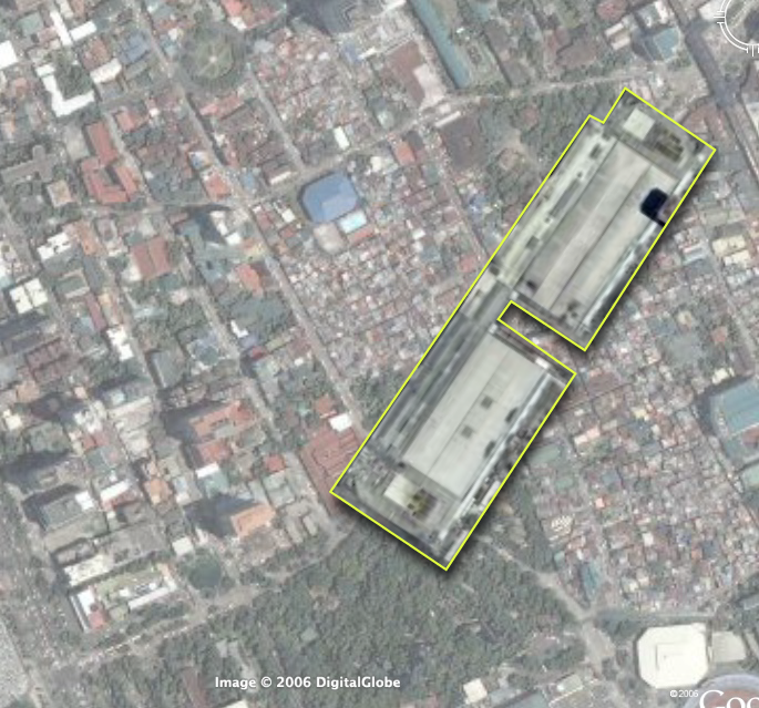
The Manila Standard reports (via Yehey News) on Quezon City's plans for building the biggest business district in Metro Manila.

(QC Mayor Sonny Belmonte) said the area would be organized into five districts: The Triangle Exchange, The Residences at Veterans, The Downtown Hub, The Emporium and The Commons.*

The 54.3-hectare Triangle Exchange will be a high-traffic commercial and residential district and the most active area of the Triangle Park.

The 40-hectare Residences at Veterans will be a mixed-use community housing condominiums and row houses, while The 54-hectare Downtown Hub will be a mixed-use, medium-density district with institutional services and facilities integrated with commercial and residential development.

The 37.9-hectare Emporium will be another mixed-use, medium-density district focused on call centers and commercial and residential developments.

The 19.8-hectare The Commons will have residential developments and recreation and entertainment establishments.
That seems to total to 152 hectares or 1.52 sq. kilometers although the press release claims 250 hectares which is just par with the 2.54 km2 that is Fort Boni. (Although the FB number is the total area for development, not specifically the CBD.)

It will still be dwarfed by the future development in Canlubang, but we could use a stronger urban center in the north of Cubao.

Elements I hope the comprehensive plan will include:
  1. Mixed income housing
  2. Walkable streets
  3. Internal transportation network
  4. Leveraging MRT (and if ever, future LRT-7) stations
  5. Public parks and open spaces (with public art!)
  6. Civic centers and civic buildings
I wonder who will get the commission? I'm sure our local architects will complain if it goes to a foreign planning firm.

Image credit: Screenshot of Google Earth

*-UDC comment: What generically boring names.


P.S. - We never did get to run with the bulls.

1.29.2007

how long...

...will it take to improve the quality of life in Metro Manila? Decades?

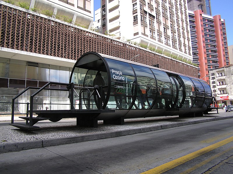
Try 3-4 years. That's according to Jaime Lernier, the the former (and famous) three-time mayor of the city of Curitiba, the capital of the Brazilian state of Parana. (He later became governor of Parana.)

Lernier, speaking last week at the World Watch Institute's State of the World 2007 briefing here in D.C., said “Every city can improve its quality of life in 3 to 4 years.”

How? Through "urban accupuncture" -that is, by "tackling urban problems at appropriate 'pressure points' (that) can cause positive ripple effects throughout entire communities."

Lerner noted that even the poorest cities can boost their standards of living by using techniques like bus rapid transit (BRT), designing multiuse buildings, and encouraging residents to live closer to their workplaces.
Lernier should know what he is talking about, he not only pioneered the Bus Rapid Transit system, he also pioneered innovative city maintenance systems such as:
  • using herds of sheep instead of tractors to keep the grass in the city parks -saving the city millions in mowing costs
  • paying fishermen to collect garbage (by the pound) from the neighboring bay -cleaning the bay in no time while giving the fishermen income year round and saving the city millions in clean-up and maintenance costs
  • trading bags of groceries and transit passes to people in slums in return for bags of garbage (cleaning up the streets in the slums which were too narrow for garbage trucks to get into)

More after the jump...

Lernier started planning and building Curitiba's Rede Integrada de Transporte in the 70's after doing a cost analysis that showed:
...that "heavy rail" like a subway costs ten times the amount for "light rail" (trolleys), which, in turn, costs ten times a bus system, even with dedicated bus ways. The "light rail" savings usually touted to sway municipal decision makers occur because even trolleys can have relatively fewer drivers than a 40 - 60 passenger bus. Lerner got Volvo to make 270-person accordion buses (300 Brazilians, says Lerner), so that was no longer an issue. The City built attractive transit stops with the look and feel of train stations -- and all the handicapped access equipment -- and got private firms to purchase and operate the buses. The city controls the routes and fares, while the private companies hire drivers and maintain equipment. (Emphasis mine-udc.)
The success of the BRT inspired Bogota's Transmilenio, Mexico City's MetroBus, Jakarta's TransJakarta Busway and a dozen other BRT projects around the world). The system was cheap, easy to roll out and easy to use:
Curitiba has a very simple and practical transportation system. Public transportation consists entirely of buses. There are several different types of bus, each with a different function.

Moving around in a car can be difficult in and around the city centre because of the many one-way streets and constant traffic jams. This makes the public transportation system more attractive if one wants to go there. (Emphasis mine -udc.) The trinary system allows quick access to the city centre for car drivers. Some avenues are spacious and laid out in a grid, and apart from some points around the city centre, Munhoz da Rocha Street and Batel Avenue, traffic jams aren't thus severe.
At the Worldwatch Institute event, Lerner also encouraged:
"greater efforts to turn chronic urban problems into innovative solutions. Curitiba, for example, converted an old landfill into the Open University for the Environment, a school that provides environmental education to citizens and policymakers at little-to-no cost. “In the city, there is no frog that can’t be turned into a prince,” Lerner says.
From wikipedia: "In June 1996, the chairman of the Habitat II summit of mayors and urban planners in Istanbul praised Curitiba as "the most innovative city in the world."

(Btw, Lernier is an architect and an urban planner. His work as mayor of Curitiba and his continuing commitment to improving the urban environment is the kind of action i'd like to see from Filipino architects.)


Image credit: One of the bus stops on Curitiba's pioneering BRT, via wikimedia commons.

12.17.2006

quirino walkable district:
opportunity sites

(Cross posted on Philippines Makeover.)

Next on our urban sketch project, let's look at the opportunities for redevelopment in our proposed walkable district. (You can catch up with parts 1 and 2 of this series.)

Focusing on the middle path -right down Quirino Avenue -we find more than 8.5 hectares right along the corridor that would be ripe for redevelopment. (Click on the picture for a larger image outlining the sites, check out the opportunity sites on Google Maps or download kml file (2.1kb).)

Also, just to give you context about the opportunity available, here are scale comparisons of the site vs. Glorietta and vs. Megamall (thumbnails after the jump).

The eleven opportunity sites are a combination of national and local government owned land and underutilized, privately owned lots. The redevelopment of the area then requires government incentives and public-private partnerships.

The largest chunks, thankfully, are in government control. The properties are also located at very strategic portions of the path. They include the two Bureau of Plant Industry (BPI) lots, the Leveriza (Manila) Children's Park and a segment of the Manila Zoo.

The two BPI lots make up about 3.3 hectares. If zoned for an FAR* of 2.5, the lots could deliver as much 890,000 sq.ft. (82,500+ sqm.) of development to the market. The lots are ideal for transit oriented development (mixed-use, with retail on the ground floor, office spaces and three to five residential towers) - taking strategic advantage of the Quirino LRT station -and catering to Makati workers, with the CBD just 7 stops (4 on LRT-1 and 3 on the MRT) and one transfer away. The residential component (condo and apartments) could also service the housing demand from students from DLSU and the other schools nearby.

The national government (BPI is under the Department of Agriculture) would do better to relocate the Bureau to where it could better serve its agricultural clientele -or where it could be closer to other agri research centers (like Los Banos). They could also require exactions from the sale, say by requiring that a percentage of the residential units be set aside for subsidized housing for public school teachers.

Meanwhile, the Manila Zoo could raise much needed funds by leasing off part of its property along Quirino. They could give up about 100 feet deep of the zoo's layout and bring about 12,000 square meters to market. (This project might already by under contemplation by the Friends of Manila Zoo Foundation, as I found a 1997 EMB circular (pdf) listing an ECC for a Manila Zoo Redevelopment Project under a company called "Zoo Village Redevelopment Corp.") This would allow the zoo to raise funds and they can also elevate the zoo's civic presence by requiring the leasee to build a structural entrance to the zoo. (Which would be way better than just the current metal sign.) The lease can also provide structured parking for the zoo.

The zoo's location at the bend of Quirino makes it ripe for a more visible structural entrance that would serve as a terminating vista, calling strollers from the corner of Qurino and Taft to walk down to the bend and the zoo entrance. The new entrance would neatly bisect our proposed pedestrian path -and serve as a waypoint from the LRT station to the bay and the baywalk.

Manila City could also raise funds and improve the services of the children's park by leasing off the property but requiring the lessee to set off the majority of the lot for a much improved children's park. The lessee can also be required to maintain the park freeing the city of the maintenance costs.

Likewise, Ospital ng Maynila could raise operational funds by leasing off its Quirino edge and its parking lot fronting the bay. They could require the lessee to provide structured parking for the hospital.

The rest of the opportunity sites are probably privately held properties and include a large empty lot (since the Google Earth image is at least a year old, the propery may not be vacant anymore), a motel, a possible defunct water storage facility and two large underutilized properties that currently house a gas station and some nominal office spaces.

The city government could provide incentives for redevelopment of these particular properties.

Here's a rundown of the sites.

Site
est. area (m2)
1. Bureau of Plant Industry 20,000
2. Bureau of Plant Industry 2 13,000
3. Empty lot 2,800
4. Manila Children's Park 12,500
5. Manila Zoo Edge 12,000
6. Motel 4,600
7. Ospital ng Maynila Edge 2,750
8. Ospital ng Maynila Parking Lot 3,800
9. Underutilized property 1 6,500
10. Underutilized property 2 4,800
11. Water storage facility (?) 2,100


Images on the left: the area compared to Glorietta (top) and Megamall (bottom). Click for larger versions.

What's missing:

If this were a full urban planning study, we would do well if we had:
  1. the zoning map for the area
  2. a property list along with a cadastral or tax assesment map
  3. current pictures of the existing buildings on the sites
Next up: Streetscape and a massing and volume study.

*Floor Area Ratio (also called Floor Space Index) = (Total covered area on all floors of all buildings on a certain plot) / (Area of the plot)

12.09.2006

quirino walkable district:
nodes and paths

(This entry cross posted at the Philippines Makeover Blog.)

Getting back to our urban planning sketch (part 1 here), one way to think about walkable districts is to think of nodes and paths. (This is pretty much a Kevin Lynch approach.)

Nodes are centers of activity - paths are...well, paths that connect the nodes. Nodes also tend to define the area around the node -turning the area into a "district" of sorts. Nodes can center around a single significant building or can be formed by a cluster of activities.

Paths of the other hand, have the power to define the edges of districts.

I've picked out the key nodes in our project area and the paths that connect them. It's important to think of nodes when planning walkable districts as the nodes serve as destinations and define the types of activities in the walkable district. The nodes also define the character of the paths - who uses the paths and what time of the day the path will be most used.

So our project area (which I am defining as the area loosely bound by the two transport nodes of the Quirino and the Vito Cruz LRT stations - and then the area west from the stations to the Bay), has several clusters of nodes -with different activities. (Click on the picture for a larger image or download the highres version here (png 3.3Mb) or download the kmz (164kb) file -with image overlay -here.)

The nodes and their surrounding activities include:

  1. The north cluster with:

    The Malate Church -with its public park foreground -and the park bordered by all day restaurants
    Remedios Circle -which is actually a barely used public park -also surrounded by restaurants -most of whom provide active nightlife to the area (UPDATE: Citizen of the World has great pics of the new Remedios Circle, and he links to Bong Austero's musings on the redesigned park), and
    the San Andres Public Market

  2. A middle cluster defined by:

    The Manila Zoo, and
    The Leveriza Children's Park (formerly Paraiso ng Batang Maynila)

  3. A south cluster with:

    The Rizal Memorial Sports Center - which also serves as a concert venue apart from sports center
    Harrison Plaza (a shopping center)

  4. Several other important destinations at the very edge of the district:

    The Metropolitan Museum
    The Manila Yatch Club
    The Cultural Center of the Philippines complex (including the FAT and the PICC)

Another major destination is, of course, the Bay itself.

Three possible pedestrian corridors (green lines) serve these clusters.
  1. A northern path from Quirino Station to Malate Church via San Andres Road (with a branch that turns north to Remedios Circle)
  2. A middle path from Quirino Station to the Bay right past the Zoo and the Children's Park (along Quirino Avenue)
  3. A southern path from the Vito Cruz Station -right up Vito Cruz St. to the CCP complex.
There are two other signficant pedestrian corridors:
  • M. Adriatico St. between Vito Cruz and Quirino (connecting Rizal Memorial and Harrison Plaza to the Zoo and the Park)
  • Roxas Boulevard (does Baywalk stretch all the way to here?) at the western edge of the district
I've color-coded the nodes -green for parks, blue for cultural (including sports), and red for commercial.

There are other ways to classify the nodes that will help us think about the activity patterns. The zoo and the park are daytime activities -while CCP, FAT and the Sport Center serve daytime activities with surge activities (major concerts and sports events) in the evening and on weekends.)

Ideally we should also have the numbers on how many people go to these nodes (both during regular hours and during surge events).

The activities, the hours, the number of people will tell us what other facilities we need in the area if we are to serve a pedestrian audience.

It's also important to consider major traffic thoroughfares (in gray) bisecting the study area, which in our case (and by order of traffic volume) are:
  • Roxas Boulevard
  • Taft Avenue
  • M. Adriatico
  • F.B. Harrison
Although Quirino (east-west) does carry some load, significant traffic flows mainly along the these north-south arterials.

(Next up, Opportunity Sites.)

Quick Links

Notable posts on the metro