the big here quiz
Kevin Kelly, Senior Maverick for WIRED magazine, posted this eco-awareness quiz on his Cool Tools blog.
It's an eye-opener of a test - specially with what I don't know about Metro Manila (or even of the current city I live and work in). I strongly suggest you take a stab at trying to answer the questions if only to enlarge your thinking of where the city begins and ends.
I've answered two of his questions here:
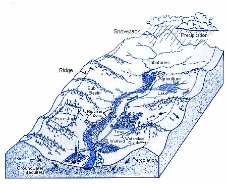
3) Trace the water you drink from rainfall to your tap.
- If you're in the East Zone of Manila -this is the probable route: your tap, main pipe, Pasig pumping station, Balara, La Mesa, Angat Dam, Angat-Umiray Rivers.
4) When you flush, where do the solids go? What happens to the waste water?
- If you're in Makati -to the Magallanes Sewage Treatment Plant, then to Tripa de Gallina, then to the Pasig, then to Manila Bay.
- If you're in Q.C. -probably to a community septic tank.
- If you're in Manila, to a CSSO (combined storm-sewer outfall) into Manila Bay.
- If you're elsewhere, you probably have a septic tank. (And when was the last time you had it drained?)
- If you're in Q.C. -probably to a community septic tank.


2 comments:
Your post made me think about how the use of directions based on North, South East, and West (i.e. Go West on Interstate 20, exit Main street South to East 1st street to the house on the Southwest side of 1st) in the country I migrated to has (atleast in my mind) given me a better feel for where I am in relation to neighborhoods, cities, states, bodies of water etc.
Compare this to typical directions (atleast up to the early 90s) in the Philippines: On Espana, drive past UST then turn right before Lerma to 1432 Halcon Street.
Is Espana a N-S street or E-W? I remember the C (circumferential roads) and R (radial roads) but they are running what direction? EDSA joins the North and South diversion roads, but it sure did not "feel" like they were directly opposite each other. EDSA "seemed" to be joining 2 highways that both (depending on orientation) you turned left to or right.
Batchmate,
I'm not sure if the directions in the US (I assume you are talking about the US) are any better orientation-wise or just better mapped and labeled. Have you ever tried driving in Boston?
The complexity of the US highway system (i-95, 1-295, 1-495 vs. rt 1, 165, 130, US 150 etc.) necessitated an accompanying labeling system (with off-ramp exit numbers) to make it navigable. Google maps and mapquest has the highway system easier to navigate.
Have you ever tried driving to somewhere without pre-referencing a map or online directions? It is just as confusing.
Manila did not need that (yet) since there were only two highways out and a couple of circumferential roads. Also, my generation didn't grow up understanding the map of metro manila (i don't think I actually saw a map of metro manila until I was in college) nor was it part of our education.
That being said, you do point out to one aspect that makes life in the city: legibility. The most legible cities are designed on a grid (like New York or Savannah.
Radial cities usually work with high point landmarks (like Paris and the Eiffel or London and Big Ben). Burnham intended this to the government center around Luneta -and Intramuros. QC has the Quezon Circle.
Post a Comment