12.31.2006

your future is (still) ayala

(Full disclosure, I used to work for Ayala Corporation.)

The Makati CBD is the Philippine's undisputed premiere financial and business district and, despite the emergence of new CBDs, is still home to both the largest businesses and the tallest buildings in the country. That it became the epicenter of Philippine commerce is a testament to good planning, good corporate governance, and the long-term vision of the country's oldest business house.

The Ayalas invested in and developed the business district back in the 1930s, when Makati was just largely empty marshland and when the growing Manila metropolis was expanding to the north (Quezon City). Under the leadership of Joseph McMicking, the Ayalas masterplanned the 1,000+ hectares, intending it to become "Asia's showcase of urban development." (This was back when Singapore was still a trading post.) It was the first large scale, fully-integrated real estate project in South East Asia, the first to feature a business and commercial core surrounded by residential development.

Today, the CBD still hosts the most expensive office spaces and the priciest land values (save for Divisoria -which, per square meter, is still the most expensive land in the country) and has propelled its host city to the top of the LGU income rankings. (Makati has been dethroned from the top rank in the last few years by an ascendant and very well-managed Quezon City.)

Some half a million pinoys work in the CBD, their incomes directly supporting another 2.5 million of the population, and indirectly supporting probably 5 times that number as consumers and as producers in the economy. The CBD has shaped not only our country's economic history, but also the political and cultural history of the last five decades.

Ayala Land, Inc. (Ayala's real estate development arm) has more up its sleeve -with a land bank that will probably shape the next 50 if not 100 years of our history. There's the 254 hectares of Fort Bonifacio -with its new masterplan, then there's the 38 hectare UP North Science Park in Diliman.

The new crown jewel will be ALI's new developments in Canlubang*which, at nearly 17 square kilometers, is 1.5 times the size of Ayala's original developments in the Makati CBD. To put that in another perspective, you can fit 6.5 Fort Bonifacio-sized developments inside the Canlubang properties -with room to spare.

Canlubang, meanwhile represents just 41% of ALI's total land bank! That means, ladies and gentlemen, that your future urban lifestyle and experience will still be shaped, in no small part, by the 170 year-old company. Your children and your grandchildren will probably be working, living or shopping in some Ayala development another hundred years hence.

* -An aside: that last link is to bworldonline article which requires subscription, but Businessworld's online edition. But Businessworld, supposedly the leading business broadsheet in the country, STILL DOES NOT TAKE online payments via credit card -and asks would be international subcribers to instead FAX their credit card details to their offices in Manila. They even ask for the security number! How backward is that in this age of identity theft?? Is their sales division led by a luddite? Could someone please, please lead them to 21st century and to the internet economy?

12.28.2006

makati rezones


The city of Makati is revising its zoning code. Zoning, for the cities that use it, is the one legal instrument that pretty much defines the fabric of built environment -and so, defines the spaces and places we live and work in.

Makati's new zoning code -well, not new, really as it is a revised zoning code -changes some of the allowed uses and ups the floor area ratio* (thereby the building intensity, e.g. how tall or how massive buildings are) in various areas of the city. I think Makati uses a traditional Euclidean or Functional zoning, defining the allowed uses (commercial, residential, office, etc.) and using FAR (floor area ratio) to prescribe building heights and bulks.

I'm saying "I think" because I couldn't find a copy of either the new or old zoning ordinance online. (Note to all city goverments: PUT YOUR ZONING CODE ONLINE!!) I did find a pdf of a powerpoint presentation (pdf 1.9mb) given to the Makati City Council sometime August of 2006 that outlined the changes.

You can navigate/check out the zoning changes on the map on this page though it might be be use the larger map as for some reason, not all my placemarkers are showing on the map on this page. The map has no street names, so you can cross reference the streets (at least for the CBD) using this flash map. If you have GoogleEarth, you can download the overlay image here (kmz 855kb file).

Over the next 5-10 years, expect to see the following changes:

  1. Convenience retail (small stores, ala 7-11) on the ground floor of the buildings along Ayala Ave. before Makati ave. and along Makati Ave. towards Paseo de Roxas.
  2. In Legaspi and Salcedo Villages, new residential towers will rise along Dela Rosa, on the backside of the office buildings along Ayala Ave. and along Valero St. (The lots there are mostly occupied by structured and surface parking. Also expect a 25% increase in building heights as they raised the FAR from 6 to 8.)
  3. We'll see more intense development (taller buildings) on the north side of Sen. Gil Puyat (Buendia) from EDSA to Ayala Ave. (the Bel-Air/Jupiter St. side).
  4. More intense commercial development is allowed between Yakal and Malugay Sts. (north of Buendia)
  5. Expect buildings to double their size/height along Pasong Tamo (on both sides of EDSA)
  6. And also more intense commercial development on Pasong Tamo before Dela Rosa
  7. Ditto for (more intense) commercial development along the western side SLEX between Zobel Roxas and Cash & Carry.
  8. More intensive neighborhood scale commercial along Zobel Roxas before SLEX
  9. Expect 30% taller buildings along both sides of the stretch of EDSA between Guadalupe and Estrella.
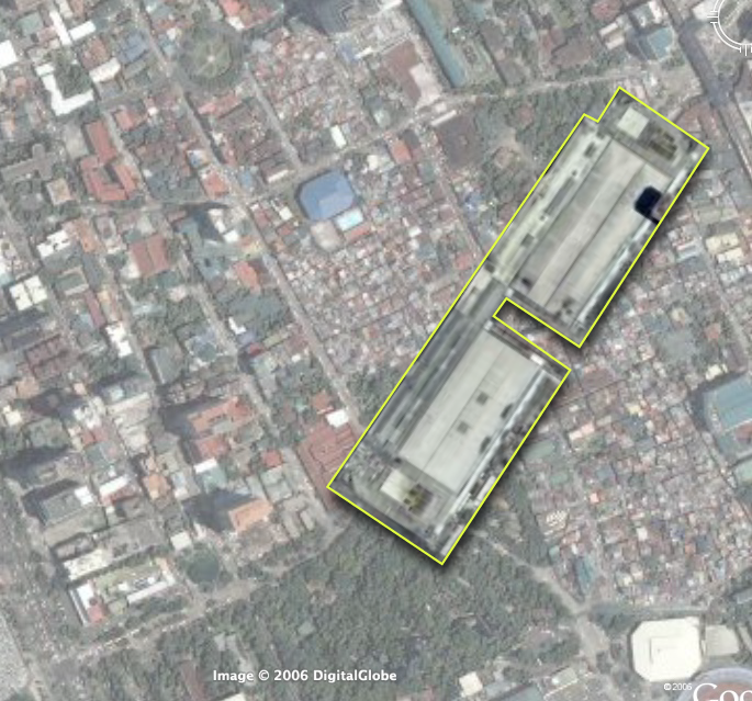
The new code also anticipates the changes in the Fort Bonifacio masterplan and greenlights the redevelopment of the old Colgate-Palmolive and SC Johnson compounds and the Metro Club into high-rise residential, office and commercial spaces. The two properties across Estrella st. from Rockwell is part of the development's expansion plan. (Looks like they will be building more residential towers and maybe some BPO office space.)

There were a few bulletpoints about "innovations" in the pdf that got me piqued, namely (my notes in italics):
  • Granting of density bonuses (bonus in exchange for what?)
  • TOD (Transit oriented development!! Where?)
  • Green spaces (public spaces, I hope! and maybe in exchange for density bonuses.)
  • Land readjustment scheme (as a way to reshape the small irregular lots in the older, low-rise, dense areas of the city)
  • Heritage zone (I guess for the old poblacion)
  • TDR (Transfer of Development Rights!!)
I'd love to see more details about this list.

Makati's new code also calls for the creation of the Office of the Zoning Administrator -which could mean more transparency and better enforcement or more bureaucracy.

I know Makati isn't alone in revising its zoning ordinance. Manila is doing it too (and I'm waiting for a friend to send me a copy of Manila's new code. Word is, they are removing heavy industrial zones and bringing in Planned Unit Development. - My comments on that new code, once I review it.)

The new zoning codes are testament to the continuing growth and change in our megacity and, hopefully, opportunities to improve our cities.

Interactive map via MapLib.Net
Here's a graphic that better explains how FAR and lot coverage define building heights and bulks.

12.26.2006

THANK YOU FUNDABLE!!!

Thank you, thank you, thank you fundable.org!!!

They forwarded the pledges we collected even if we didn't hit the target!

Merry Christmas, Jack!

Thank you to everyone who pledged! (and may I add #46. Adi A. who pledged with 20 minutes left to go.)

Thank you to Wily Priles, Amalah and Vickie for posting about Jack. And to Raymond V., Aimee A. and Mai T. for spreading the word.

Tiny Tim puts it best, "God bless us, everyone!"

visualizing density

After reading this article from Fortune (forwarded by Sol), I worked out a 3d chart using wikipedia data comparing the relative land areas and population densities of a few megacities.

The chart represents land area in square kilometers along the x,y axis (width and depth), and population density in people per square kilometer along the z axis (height).

The tall red column represents Metro Manila's density and area vs. other megacities. We're nearly three times the density of Hongkong occupying little more than half HK's land area. Even Mumbai distributes its density a little better.

the truth about google earth


Found this YouTube video via urban cartography.

Now, if I could only pick up those damned billboards with my cursor...

12.24.2006

1 day and more than $2K to go

With little more than a day and still $2,025 short, it looks like we won't hit our $5,000 target for Jack's fundable campaign. The rules are, if we don't hit the target, fundable will not collect any of the pledges.

(Read about Jack here. And here.)

It is a big disappointment for us -and we feel we've let Jack down. We tried our best and we asked as many people as we could.

Thank you so much to the following dear friends who did pledge:

  1. Abby C.
  2. Aimee A.
  3. Alex And Alexis S.B.
  4. Alice M.
  5. Amanda S.
  6. Amy S.
  7. Anna A.
  8. Baly C.
  9. Beatriz L.
  10. Candice C.
  11. Catherine L.
  12. Claire S.
  13. Daniel M.
  14. Elaine D.
  15. Elaine M.
  16. Elizabeth H.
  17. Ellen T.
  18. Eric And Daisy Dlp.
  19. Essa R.
  20. Frederik F.
  21. Georgia B.
  22. Isabel F.
  23. Ivy A.
  24. Jennifer H.
  25. Jennifer S.
  26. Jenny C.
  27. Jonathan L.
  28. Joselito A.
  29. Leah K.
  30. Lia U.
  31. Lola R.
  32. Mai T.
  33. Malyn K.
  34. Margaret M.
  35. Maria Cecilia T.
  36. Martin H.
  37. Michelle G.
  38. Michelle M.
  39. Paul E.
  40. Rajendra S.
  41. Raymond V.
  42. Reine P.
  43. Stacie T.
  44. Therese L.
  45. Yael A.
Maybe's 24 hours is still enough time for a miracle.

Even then, all is not lost. If we don't hit the target, then will ask our friends to send their check directly to Jack's grandmother:
Rita S. Simbulan
548 S. Normandie Ave., Apt. 1, Los Angeles, CA 90020
Office - (213) 747-5588 Ext. 233 - 9 a.m. to 5:30 p.m., Pacific Time
Cellphone (213) 447-3587
Email: emerald5172 at yahoo.com
Office Email: rita at veniceinvestments.com
We'll keep praying -and we hope you say a prayer or two for Jack and his parents, and all the other children and families suffering through faconi anemia. May they find joy this season through and despite the struggle.

Merry Christmas.

12.23.2006

landcraft!

Very very addictive! Specially for mapgeeks.

Generate your own landscapes, ala SimCity's God Mode.

Try it here.


(nothing follows)

12.22.2006

the greening of seoul

The Guardian Weekly reports on the Seoul's demolition of a major highway and the restoration of a river and a park in its place:

"The demolition of a vast motorway through the centre of South Korea's capital and the restoration of a river and park in its place proves that mega-cities can be changed for the better. One year ago this month, several million people headed to a park in the centre of Seoul, the capital of South Korea and seventh-largest city in the world. They didn't go for a rock festival, a football match or a political gathering, but mostly to just marvel at the surroundings, to get some fresh air and to paddle in the river."

...in a revolutionary act of ecological restoration that is now being examined around the world, the city of Seoul, under the leadership of the then mayor, Lee Myung Bak, pledged in 2002 to restore the river, tear down the motorway and create a 8km-long, 800-metre wide, 400ha lateral park snaking through the city where the river once ran."
Here's the clincher: tearing down the motorway did NOT result in the traffic nightmare the naysayers were predicting:
"We discovered it was a case of 'Braess paradox', which says that by taking away space in an urban area you can actually increase the flow of traffic, and, by implication, by adding extra capacity to a road network you can reduce overall performance." (emphasis mine -urbano)

[Kee Yeon Hwang, a professor in the department of urban planning and design at Hongik University -and the principal author of the masterplan] said: "The tearing down of the motorway has had both intended and unexpected effects. As soon as we destroyed the road, the cars just disappeared. A lot of people just gave up their cars. Others found a different way of driving."
Which should be something Metro Manila's traffic planners should think about everytime they decide that the best way to solve the traffic mess is to widen the roads and build more flyovers. (Read more about Braes and the Road Network Paradox.)

The other gem was the impact on the environment -apart from just the river restoration:
"We found that surface temperatures in summer along the restored river were an average 3.6C lower than 400 metres away. The river is now a natural air-conditioner, cooling the capital during its long hot summers. Average wind speeds in June this year were 50% higher than the same period last year.”
Says Treehugger:
"Citizens flock to the water's edge--there are waterfalls, play spaces, running tracks and sitting areas. Birds, fish, plants and a variety of wildlife have also returned and increased. Shanghai and Los Angeles are looking at the results because Cheonggyecheon Park has become a model for other large cities seeking to link regeneration and environmental progress."

It also should inspire us to consider daylighting some of the esteros that we have paved over, and seriously pursuing the restoration of the Pasig. It should, like Cheonggyecheon Park, serve as the major public amenity for our metropolis.

Here's the link to the full article and the post on Treehugger.

12.17.2006

quirino walkable district:
opportunity sites

(Cross posted on Philippines Makeover.)

Next on our urban sketch project, let's look at the opportunities for redevelopment in our proposed walkable district. (You can catch up with parts 1 and 2 of this series.)

Focusing on the middle path -right down Quirino Avenue -we find more than 8.5 hectares right along the corridor that would be ripe for redevelopment. (Click on the picture for a larger image outlining the sites, check out the opportunity sites on Google Maps or download kml file (2.1kb).)

Also, just to give you context about the opportunity available, here are scale comparisons of the site vs. Glorietta and vs. Megamall (thumbnails after the jump).

The eleven opportunity sites are a combination of national and local government owned land and underutilized, privately owned lots. The redevelopment of the area then requires government incentives and public-private partnerships.

The largest chunks, thankfully, are in government control. The properties are also located at very strategic portions of the path. They include the two Bureau of Plant Industry (BPI) lots, the Leveriza (Manila) Children's Park and a segment of the Manila Zoo.

The two BPI lots make up about 3.3 hectares. If zoned for an FAR* of 2.5, the lots could deliver as much 890,000 sq.ft. (82,500+ sqm.) of development to the market. The lots are ideal for transit oriented development (mixed-use, with retail on the ground floor, office spaces and three to five residential towers) - taking strategic advantage of the Quirino LRT station -and catering to Makati workers, with the CBD just 7 stops (4 on LRT-1 and 3 on the MRT) and one transfer away. The residential component (condo and apartments) could also service the housing demand from students from DLSU and the other schools nearby.

The national government (BPI is under the Department of Agriculture) would do better to relocate the Bureau to where it could better serve its agricultural clientele -or where it could be closer to other agri research centers (like Los Banos). They could also require exactions from the sale, say by requiring that a percentage of the residential units be set aside for subsidized housing for public school teachers.

Meanwhile, the Manila Zoo could raise much needed funds by leasing off part of its property along Quirino. They could give up about 100 feet deep of the zoo's layout and bring about 12,000 square meters to market. (This project might already by under contemplation by the Friends of Manila Zoo Foundation, as I found a 1997 EMB circular (pdf) listing an ECC for a Manila Zoo Redevelopment Project under a company called "Zoo Village Redevelopment Corp.") This would allow the zoo to raise funds and they can also elevate the zoo's civic presence by requiring the leasee to build a structural entrance to the zoo. (Which would be way better than just the current metal sign.) The lease can also provide structured parking for the zoo.

The zoo's location at the bend of Quirino makes it ripe for a more visible structural entrance that would serve as a terminating vista, calling strollers from the corner of Qurino and Taft to walk down to the bend and the zoo entrance. The new entrance would neatly bisect our proposed pedestrian path -and serve as a waypoint from the LRT station to the bay and the baywalk.

Manila City could also raise funds and improve the services of the children's park by leasing off the property but requiring the lessee to set off the majority of the lot for a much improved children's park. The lessee can also be required to maintain the park freeing the city of the maintenance costs.

Likewise, Ospital ng Maynila could raise operational funds by leasing off its Quirino edge and its parking lot fronting the bay. They could require the lessee to provide structured parking for the hospital.

The rest of the opportunity sites are probably privately held properties and include a large empty lot (since the Google Earth image is at least a year old, the propery may not be vacant anymore), a motel, a possible defunct water storage facility and two large underutilized properties that currently house a gas station and some nominal office spaces.

The city government could provide incentives for redevelopment of these particular properties.

Here's a rundown of the sites.

Site
est. area (m2)
1. Bureau of Plant Industry 20,000
2. Bureau of Plant Industry 2 13,000
3. Empty lot 2,800
4. Manila Children's Park 12,500
5. Manila Zoo Edge 12,000
6. Motel 4,600
7. Ospital ng Maynila Edge 2,750
8. Ospital ng Maynila Parking Lot 3,800
9. Underutilized property 1 6,500
10. Underutilized property 2 4,800
11. Water storage facility (?) 2,100


Images on the left: the area compared to Glorietta (top) and Megamall (bottom). Click for larger versions.

What's missing:

If this were a full urban planning study, we would do well if we had:
  1. the zoning map for the area
  2. a property list along with a cadastral or tax assesment map
  3. current pictures of the existing buildings on the sites
Next up: Streetscape and a massing and volume study.

*Floor Area Ratio (also called Floor Space Index) = (Total covered area on all floors of all buildings on a certain plot) / (Area of the plot)

12.13.2006

steven johnson on
the challenge of the megacities

Steven Johnson (of "Emergence" -one of my favorite books on understanding cities) continues his Urban Planet blog for the New York Times with a look at the challenges of today's megacities --comparing them to the challenges of victorian age London (which he documents in his new book "The Ghost Map").

He cites Robert Neurwith's "Shadow Cities" -and rings a bell of hope for today's urban agglomerations -and pretty much echoes my own reasons for feeling positive about Metro Manila.

If London could transform itself so dramatically in a matter of decades, there’s at least reason to hope that the megacities of the developing world can do the same. They have populations 10 times the size of Victorian London’s, but they have one crucial advantage: most of the problems they face we already know how to solve. The Victorians had to invent a whole set of institutions — and learn from a long list of scientific breakthroughs — in order to make large-scale metropolitan living into a sustainable practice. But now we know how to prevent cholera; we know how to build sewer systems and water-treatment plants; and we can identify and track emerging diseases with an accuracy that would have astonished the scientists of the 19th century.
Read the rest of Johnson's article via NYT here (subscription). - Whole article after the jump.

December 12, 2006, 10:28 pm
The Challenge of the Megacities
By Steven Johnson

I began these posts with a look back at the squalor and terror of London 150 years ago, a city literally drowning in its own filth, ravaged by disease, and haunted by a scavenger class living off the refuse of the city — a group so large in number that had they broken off and formed their own city, it would have been the fifth largest in England. My trip to London last week brought yet another reminder of the immense progress the city — like most other cities in the developed world — has made in a relatively short time. The air and water are far cleaner; the killer epidemics of the Victorian age have been vanquished; life expectancies have doubled; and overall standards of living are significantly higher than they were in the 1850s.

But something else has changed since then. London was the largest city on the planet back in 1854, but now it is on the smaller side, as world cities go. (It ranks in the mid-teens, depending on how you define its borders.) Many of the cities that now top the charts — Mexico City, Sao Paulo, Mumbai — have as much in common with Victorian London as they do with the modern version. London’s hundred thousand scavengers are a mere footnote compared to the massive shantytowns that have exploded at the margins of today’s megacities.

These squatter communities have been built on land that is, technically speaking, illegally occupied — without official title deeds, electricity, running water or waste removal systems. (Underground economies providing all these services have started to develop, however.) In such places, the waterborne diseases — including cholera — that plagued the Victorians are still rampant, thanks to miserable public health and sanitation resources.

The squatters worldwide now add up to a billion people, and some experts project that by 2030, a quarter of the world’s population will live in shantytowns. This is not entirely reason for despair. As the writer Robert Neuwirth argues in his extraordinary book “Shadow Cities,” shantytowns are places of dynamic economic innovation and creativity. Some of the oldest ones — the Rocinha area in Rio de Janeiro, Squatter Colony in Mumbai — have already matured into fully-functioning urban areas with most of the comforts we’ve come to expect in the developed world. Improvised wood shacks have given way to steel and concrete, electricity, running water, even cable television.

If London could transform itself so dramatically in a matter of decades, there’s at least reason to hope that the megacities of the developing world can do the same. They have populations 10 times the size of Victorian London’s, but they have one crucial advantage: most of the problems they face we already know how to solve. The Victorians had to invent a whole set of institutions — and learn from a long list of scientific breakthroughs — in order to make large-scale metropolitan living into a sustainable practice. But now we know how to prevent cholera; we know how to build sewer systems and water-treatment plants; and we can identify and track emerging diseases with an accuracy that would have astonished the scientists of the 19th century.

This is reason for both hope and for shame. Cholera itself is so easily treatable that, in controlled laboratory experiments the United States, test subjects can be safely infected with the bacterium. And yet water-related diseases including cholera still kill up to 5 million people a year worldwide, many of them in squatter communities. The hope lies in the fact that we know how to stop these deaths. The shame is that we haven’t actually managed to do it yet.


Image credit: S. Johnson in London, via stevenberlinjohnson.com

Quick Links

Notable posts on the metro