Showing posts sorted by relevance for query makati land use. Sort by date Show all posts

12.28.2006

makati rezones


The city of Makati is revising its zoning code. Zoning, for the cities that use it, is the one legal instrument that pretty much defines the fabric of built environment -and so, defines the spaces and places we live and work in.

Makati's new zoning code -well, not new, really as it is a revised zoning code -changes some of the allowed uses and ups the floor area ratio* (thereby the building intensity, e.g. how tall or how massive buildings are) in various areas of the city. I think Makati uses a traditional Euclidean or Functional zoning, defining the allowed uses (commercial, residential, office, etc.) and using FAR (floor area ratio) to prescribe building heights and bulks.

I'm saying "I think" because I couldn't find a copy of either the new or old zoning ordinance online. (Note to all city goverments: PUT YOUR ZONING CODE ONLINE!!) I did find a pdf of a powerpoint presentation (pdf 1.9mb) given to the Makati City Council sometime August of 2006 that outlined the changes.

You can navigate/check out the zoning changes on the map on this page though it might be be use the larger map as for some reason, not all my placemarkers are showing on the map on this page. The map has no street names, so you can cross reference the streets (at least for the CBD) using this flash map. If you have GoogleEarth, you can download the overlay image here (kmz 855kb file).

Over the next 5-10 years, expect to see the following changes:

  1. Convenience retail (small stores, ala 7-11) on the ground floor of the buildings along Ayala Ave. before Makati ave. and along Makati Ave. towards Paseo de Roxas.
  2. In Legaspi and Salcedo Villages, new residential towers will rise along Dela Rosa, on the backside of the office buildings along Ayala Ave. and along Valero St. (The lots there are mostly occupied by structured and surface parking. Also expect a 25% increase in building heights as they raised the FAR from 6 to 8.)
  3. We'll see more intense development (taller buildings) on the north side of Sen. Gil Puyat (Buendia) from EDSA to Ayala Ave. (the Bel-Air/Jupiter St. side).
  4. More intense commercial development is allowed between Yakal and Malugay Sts. (north of Buendia)
  5. Expect buildings to double their size/height along Pasong Tamo (on both sides of EDSA)
  6. And also more intense commercial development on Pasong Tamo before Dela Rosa
  7. Ditto for (more intense) commercial development along the western side SLEX between Zobel Roxas and Cash & Carry.
  8. More intensive neighborhood scale commercial along Zobel Roxas before SLEX
  9. Expect 30% taller buildings along both sides of the stretch of EDSA between Guadalupe and Estrella.
The new code also anticipates the changes in the Fort Bonifacio masterplan and greenlights the redevelopment of the old Colgate-Palmolive and SC Johnson compounds and the Metro Club into high-rise residential, office and commercial spaces. The two properties across Estrella st. from Rockwell is part of the development's expansion plan. (Looks like they will be building more residential towers and maybe some BPO office space.)

There were a few bulletpoints about "innovations" in the pdf that got me piqued, namely (my notes in italics):
  • Granting of density bonuses (bonus in exchange for what?)
  • TOD (Transit oriented development!! Where?)
  • Green spaces (public spaces, I hope! and maybe in exchange for density bonuses.)
  • Land readjustment scheme (as a way to reshape the small irregular lots in the older, low-rise, dense areas of the city)
  • Heritage zone (I guess for the old poblacion)
  • TDR (Transfer of Development Rights!!)
I'd love to see more details about this list.

Makati's new code also calls for the creation of the Office of the Zoning Administrator -which could mean more transparency and better enforcement or more bureaucracy.

I know Makati isn't alone in revising its zoning ordinance. Manila is doing it too (and I'm waiting for a friend to send me a copy of Manila's new code. Word is, they are removing heavy industrial zones and bringing in Planned Unit Development. - My comments on that new code, once I review it.)

The new zoning codes are testament to the continuing growth and change in our megacity and, hopefully, opportunities to improve our cities.

Interactive map via MapLib.Net
Here's a graphic that better explains how FAR and lot coverage define building heights and bulks.

9.11.2007

new cities in new valleys


I've talked about Ayala Land's vast land holdings in Canlubang before and how that will definitely figure into the future of our megacity. Apparently they've laid out the vision of the shape of that new development. (Ah, the tribulations of unrequited and long distance love - when you live and work away from the city you call home. News gets by without you.)

Jo, the ManilaRat, keyed me in on the developments in Nuvali in her latest post.

Heard about AyalaLand's new project in Canlubang, called Nuvali (from the Latin nuvo meaning "birth of a star"). Literally a "new valley" in the Sta. Rosa-Tagaytay area, it's a 1,600-hectare megatownship development set for full bloom over the next 40 to 50 years. Eyed as the next Makati, its main thrust is 21st century technology meets back-to-basics harmony with nature. Think eco-friendly, ultra-modern sustainable living: clean lines, fluid designs, integrated zones (residential, business, services), and green green green everywhere.
So I hied off to the Ayala Land site (and noticed how it seems to be so geared towards the OFW -or Pinoy Expats, as Dave Llorito prefers -market) and jumped off to Nuvali site. (Warning: bad UI flash-based website.)

I was eager to look for broad sketch masterplans but all the site had was spiffy marketing marterial. You can download pdf copies of an ad series about Nuvali that they ran in the Philippine Star. (Another warning: they make you pass through a copyright agreement. -duh!)

The content is worth it, if you can stand the marketing speak ("evoliving" -? really???) and the weird commitment to pseudo-italian placenames ("Abrio" -?!?). The sidebar on "design and planning initiatives" (see below) were significant.


I'll definitely cheer for de-emphasizing cars and multi-use (read: mixed-use) neighborhoods. Kudos also to a "future that veers away from the severe sprawl of conventional urban development."

To that end, Joel Luna, Chief Architect of the Ayala Land Innovation and Design Group, says they are building wider sidewalks:

"...to encourage more people to walk rather than take their car. This is also safer and more pedestrian friendly. We are also building narrower pavements...so there's more room for natural landscaping. There will be double-rows of trees instead of the typical single row."

So their are paying attention to pedestrian mobility and comfort -and the micro-climate.

Then there's this sidebar:


Can Ayala accomplish all this? Despite the marketing gloss, I have no doubt that they will. They are patient enough and forward looking enough (remember it took them 50 years to fully develop the Ayala CBD, and they waited close to decade for Metro Pacific to go belly up on Fort Bonifacio -and now it's in their control) and have the deep pockets to see this through.

The one aspect I will be looking closely at: whether they can escape their elitist past and be willing to mix incomes and avoid the segrated, gated, high-walled enclaves that I suspect add to the (spatial) roots of our discontent.

It'll probably take about 5-10 years to get the full expanse of the project - another 10 to fully build out the infra, but this will definitely be another mega-project that will shape the future of our megacity.

Image credit: swiped from ALI's website
doesn't this cover fair-use?


(p.s. -er, nuvali? can we change the name? to something a little more asian? spanish even?)

7.25.2006

going mental 4: walled out and edgeless


Going back to our conceptual analysis of Metro Manila. Take a look at the first image.

Where does metro manila physically end? I know there are the political boundaries of the NCR cities and municipalities -but as far as actual scope of urbanization, where does it end? When do you know you've left the city and have entered the countryside?

Cavite, Laguna and Batangas are becoming as intensely urban as southern Metro Manila and the metropolis has become edgeless. (Calabarzon actually has a larger population than the NCR. The Southern Tagalog urbanized population is also growing faster than the NCR.)

This blurred edge was also hastened by the loophole in Agrarian Reform Law that allowed landowners to keep their holdings if the land was no longer in agricultural use. Most of Cavite's once productive farmlands are now zoned for other uses (commercial, industrial or residential).

Our metropolis not only sprawls north, south and east but it also is largely homogenous - residential subdivision after residential subdivision -variagated only only in housing size and income.

It is income that largely differentiates and defines our residential districts. The metropolis is quartered by gated communities that often frustrate effective transportation and traffic patterns.

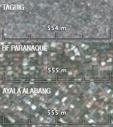
The second image shows the differing grain in house size that also stands in for the economic strata of the residents -from Ayala Alabang (A), to BF Paranaque (A and upper B) to Taguig (C & D).

What makes these gated villages different from the rest of the metropolis is that value of land inside the gates tends to appreciate faster than the rest of the metropolis. (And yet the size of the middle and upper class does not seem to be expanding so it makes you wonder if the rich are only selling to themselves.)

In cities that grew up before the automobile (i.e. -their transport options included walking, animal drawn carriages or trains), you can take the land values map and it will almost mirror the relative heights of buildings. More expensive land tends to encourage taller buildings. Land that is also more connected by infrastructure (i.e. -the closer you are to a mass transit station) also tends to command a higher price.

Two forces drive the alternative effect in our metropolis: In a polycentric city like ours (like LA and Atlanta), the land values correspond to preferred elite communities -and reflect the value in shared amenities that the original developer put in (i.e. -roads, sewer, water, trees, parks etc. -as well as security). The other driving force is adjacency to high value commercial property (think the gated communities of the Makati CBD or Greenhills and the Valle Verdes) -or a private amenity such as a golf course or a premier university (think Wakwak, Ayala Heights or Ayala Alabang.)

Our gated communities also echo the historic intra of the Intramuros. To the extramuros (the arraballes of old) belong the great unwashed -the service people and the crop growers who tend the fields and businesses owned by the elite living inside the gates. (See Carlos' outstanding essay on the demise of the mestizo class.)

It also reflects the inverse level of investment (by the national and local governments) in public facilities outside the gated communities. While the edgeless sprawling urbanity is the built on the relative weakness of the agrarian economy in lands adjacent to the metropolis.

The good news is gated communities are not unique to Metro Manila. Other cities suffer the same kind of economic segregation and are searching for politically palatable (read: incentives) options to get the gates open. We will learn from their innovations.

2.01.2008

greens heart cities

Or why environmentalists should learn
to love Metro Manila


Do you consider yourself an environmentalist? Do you like the great outdoors and natural landscapes? Do you want to preserve them? -- Then you should be concerned about our cities and should be committed to making them better places to live:

The NYT's Dot Earth blog neatly sums up the reasons why:
Urban life can be productive and satisfying and is almost always much more efficient in terms of energy and land use. Families are smaller. Incomes can rise quicker. Wealth builds from the concentration of capital and enterprise. Pollution is concentrated, too, but that makes it easier to clean up once incomes grow enough to pay for municipal services. (That hasn’t happened yet in many developing-country cities.) -emphasis added- UDC

The post that comes from is about managing traffic in an urban age but that one paragraph should be read and re-read by every pinoy environmentalist.

Environmentalism is so often associated with pastoral or naturalistic scenes; with climbing Mt. Apo, Pinatubo or Makiling; with swimming with the whale sharks in Donsol or with diving and exploring the Tubataha reefs. But, sustainability must begin with cities. If we can manage our land consumption and clean up our cities, we will do so much more towards protecting our environment.

Next time you and your friends plan on an environmental education trek, don't bother to drive out all the way to the countryside. Plan a walking tour of your local metropolis, instead. And then ask yourselves, "What can we do to make life in the city more livable? What can we do to make Philippine urban development more sustainable?"


7.10.2006

going mental (3.a) -confluences and waterfronts


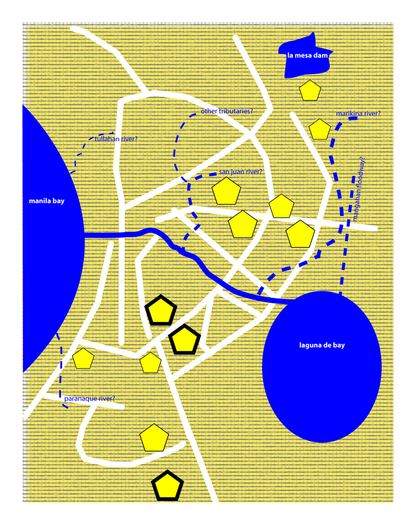
above: conceptual map of metro manila with
suggested areas to celebrate the waterfront.


below: four opportunity sites at the confluence
of the pasig and the san juan rivers


So how do we reconnect to our bay, our lake and our rivers? How do we bring them back into our shared imaginations of our cities?

To do that, we have to celebrate our rivers, our lake and our bay. We have to celebrate them as places -and with places. Physical places where we can see and approach the water. Where the waters can reclaim their rightful place in our imagination.

Fortunately for us, waterfronts offer some of the easiest areas for redevelopment -specially in old industrial cities. Most watefronts are occupied by old industrial sites which used to use the water for transport (hence the location). Most have been either abandoned, or given over to unprofitable uses.

Cities all over the world have rediscovered and reinvested in their waterfronts. Check out False Creek in Vancouver, or London's Canary Wharf (also this), or Singapore's Boat Quay, or the Cambridgeside Galleria in Cambridge, Massachusetts -all of these were former decrepit industrial sites that were redeveloped by public and private funds, through the creation of innovative policy tools and investment vehicles.

We've started on that road somewhat -with Marikina's Riverbanks, and Manila's Baywalk. Hopefully, the expansion of Rockwell into the old Noah's Ark Sugar factory property and the old Colgate-Palmolive factory will incorporate riverfront access. So too, I hope, Ayala's redevelopment of the Sta. Ana racetrack.

If I had my druthers, I would turn the whole stretch of the pasig from the bay to the palace into a "riverwalk" -anchored on one end by the Intramuros and Fort Santiago and by Malacanang on the other -with the Arroceros Forest Park and a re-oriented Liwasang Bonifacio as gems in between. (Why hasn't anyone redeveloped Quiapo Ilalim?) -And I would celebrate where the waters meet -river to river, river to bay. (See conceptual map to the right.)

I looked through Google Earth and identified at least 14 brownfield opportunity sites along the Pasig - notably at it's confluences with the San Juan and the Marikina -that are ripe for redevelopment. (Apart from the the manila oil depot -which really should move out of the city.)

Four are in Sta. Ana and Sta. Mesa -on an interesting loop of land right where the San Juan meets with the Pasig (see picture to the right). There are large swaths of land in Mandaluyong and Makati, along the banks of the Pasig near EDSA, and then even more right where the Marikina meets the Pasig. There are sites just east of C-5 and more south of Eastwood City (which, incidentally made the mistake of turning its back on the river.)

I do not know how productive these properties are currently, but they would be great to redevelop into mixed-use, commercial, business and residential properties. The concerned cities should reassemble these lands - invest in the demolition and remediation (clear up any toxic messes) -then create public-private reinvestment companies to redevelop the sites. The tradeoffs (in return for the public investment) should be that the redevelop sites should set aside the waterfront for publicly accesible parks or public open spaces and that a percentage of the residential development should be affordable housing.

I've posted the 14 sites I selected on Google Earth Philippines where you can download the kml file. Or you can view the sites via Google Maps.

P.S.

"What about the pollution?" you say. "Have you smelled the Pasig?" - Well one of the things we've discovered about redeveloping waterfronts -of placing parks next to the water -is that it only increases awareness and concern for the state of the rivers and lakes. The redeveloped sites become valuable opportunities (and venues) for educating the public about water -and the role it plays in our lives. (See this project in Chengdu, China.)

The redeveloped sites could also be required to build in passive (or active) water treatment or bioremediation facilities such as living machines. (See also this example and this one.)

(If you spot other places for redevelopment, send your kml file to Google Earth Philippines -or send us suggestions on Philippines Makeover.)

3.26.2006

transport and development


Image credit: Salt Lake City TOD and Multi-modal hub by the IBI Group.

This article came out a month ago (Feb. 24, 06) in BusinessWorld's online edition. I've only included segments of the article -and all emphasis (italics) is mine:

Northrail woos Ayala for railway project


The North Luzon Railways Corp. (Northrail) has invited the Ayala group to look into the possibility of putting up malls that would serve as train terminals for the railways system in a bid to reduce government's cost for the project.

In an interview, Northrail President Jose Cortes, Jr. told BusinessWorld the company had pitched the idea to the Ayala group in a letter.

"We have conveyed it in writing and we're just waiting for them to reply. The letter was to inform them of our interest to join whatever activities they have along the way. If they set up a mall, we'll be willing to put the rail station in the same area to give them the market," Mr. Cortes said.

Northrail, which will initially run from Caloocan to Malolos, Bulacan, will have six stations for the first phase -- Caloocan, Valenzuela, Marilao, Bocaue, Guiguinto and Malolos.

Malls that will serve as terminals for the train system could benefit from the 164,743 passengers that Northrail will transport daily once it starts operations. Northrail said the number of passengers it will transport will later increase to 363,193 daily.

Mr. Cortes said Northrail is giving Ayala the option to choose which terminals it would want to put a mall in. "It would depend on what properties they have," he said.

Ayala Land, Inc. spokesman Jan Bengzon said the company is not as yet in the position to say if it is interested in the proposal. "All I can say is we're looking at it, as I'm sure other developers are," he said.

...The SM Group, meanwhile, has already signified interest in putting up malls in some areas that are designated for Northrail terminals.

"They are just waiting for the terms of reference," Mr. Cortes said.

Among others, the SM group would like to know if the Northrail stations would pass through its existing malls in the north. SM has malls in Valenzuela and Marilao, and is putting up a mall in Clark, which Northrail could later use as a terminal once the project is extended all the way to the Clark Special Economic Zone.

Mr. Cortes added mayors of the towns that Northrail will be passing through are also talking with the Gokongweis and other mall owners for the possibility of putting up malls that would serve as train stations.

Northrail is asking mall owners to build malls that would serve as terminals for the railways system to lower its costs. Mr. Cortes earlier said that if Northrail builds the terminals itself, it will only be able to allocate P5 million per station.
Well congratulations to Northrail for at least being creative about financing and seeing the potentials of the rail stations.

BUT the rail stations could be so much more.

First of all, how strategic is it to put the stations where the malls are? They should site the stations based on access and density (i.e. -how will people get to the stations, what towns should it serve) -and then invite the malls to locate.

We already made the mistake of locating MRT stations near malls rather than the logical pedestrian and multi-modal junctions. Let's not make that mistake with Northrail.

Transport access will decide development -i.e. build the trains and the malls will definitely follow.

Second, instead of just malls, they should create (say it with me folks): TRANSIT ORIENTED DEVELOPMENT, i.e-not just malls, please, but also housing. and offices.

Think of it, you could live in a station in Marilao -and take the train in to get to Fort Boni or the Makati CBD. Or you could build call centers on top of commercial centers (which we are already doing) on top of the train station. Add medium rise housing within 4/5 of a kilometer (about a 5 minute walking distance) and you have the beginnings of a transit village. Creating opportunities within a radius of .8Km will yield about 2M sq.m. of developable land. At a comfortable 20 dwelling units per acre - each station could provide more than 10,000 units of housing. At an optimal 50du/acre -stations could generate 25,000 housing units. (Not to mention at least 100,000 extra-riders and commercial customers from each station.)

And with office and commercial in the mix -there will be lots of opportunities for cross-subsidies, allowing the developer to either 1) offer below market rates for the housing or 2) set aside a large percentage of the housing for low income families. (And an opportunity to provide rental housing -to help solve the housing backlog.)

I'm sure the pro-forma would show a healthy balance sheet. HUDCC should get involved in this. And the mayors shouldn't just be looking at malls - they should consider rezoning around the stations to make them ready for transit oriented development, and create TOD friendly urban plans that encourage walking to the station.

Third, use the stations to spur development in existing centers - locate them near our old communities to open up investment possibilities in these old towns and cities.

Fourth, the stations are opportunities for civic infrastructure - for buildings that inspire and tell a story about what we want our country to be. Don't let the malls decide what the stations will look like (unless SM's concrete boxes or the Gokongwei malls fill your heart with civic pride).

The northrail investment is going to be huge and could be hugely strategic if the managers can think outside the box of trains-as-a-solution-to-congestion (i.e.- traffic reduction) and begin to think of the lines and nodes as opportunities to reshape both the built fabric of the city and the dynamics of our urban economies.

(For more information about what transit oriented development is, visit the Center for Transit Oriented Development site. For more on the benefits of TOD and strategies for implementation, visit the Rail-volution 2005 conference site to download the speaker presentations.)

12.17.2006

quirino walkable district:
opportunity sites

(Cross posted on Philippines Makeover.)

Next on our urban sketch project, let's look at the opportunities for redevelopment in our proposed walkable district. (You can catch up with parts 1 and 2 of this series.)

Focusing on the middle path -right down Quirino Avenue -we find more than 8.5 hectares right along the corridor that would be ripe for redevelopment. (Click on the picture for a larger image outlining the sites, check out the opportunity sites on Google Maps or download kml file (2.1kb).)

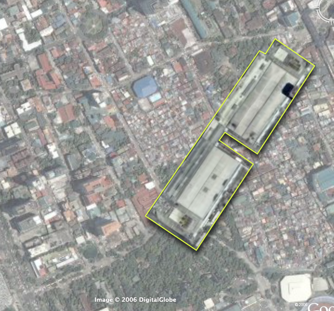
Also, just to give you context about the opportunity available, here are scale comparisons of the site vs. Glorietta and vs. Megamall (thumbnails after the jump).

The eleven opportunity sites are a combination of national and local government owned land and underutilized, privately owned lots. The redevelopment of the area then requires government incentives and public-private partnerships.

The largest chunks, thankfully, are in government control. The properties are also located at very strategic portions of the path. They include the two Bureau of Plant Industry (BPI) lots, the Leveriza (Manila) Children's Park and a segment of the Manila Zoo.

The two BPI lots make up about 3.3 hectares. If zoned for an FAR* of 2.5, the lots could deliver as much 890,000 sq.ft. (82,500+ sqm.) of development to the market. The lots are ideal for transit oriented development (mixed-use, with retail on the ground floor, office spaces and three to five residential towers) - taking strategic advantage of the Quirino LRT station -and catering to Makati workers, with the CBD just 7 stops (4 on LRT-1 and 3 on the MRT) and one transfer away. The residential component (condo and apartments) could also service the housing demand from students from DLSU and the other schools nearby.

The national government (BPI is under the Department of Agriculture) would do better to relocate the Bureau to where it could better serve its agricultural clientele -or where it could be closer to other agri research centers (like Los Banos). They could also require exactions from the sale, say by requiring that a percentage of the residential units be set aside for subsidized housing for public school teachers.

Meanwhile, the Manila Zoo could raise much needed funds by leasing off part of its property along Quirino. They could give up about 100 feet deep of the zoo's layout and bring about 12,000 square meters to market. (This project might already by under contemplation by the Friends of Manila Zoo Foundation, as I found a 1997 EMB circular (pdf) listing an ECC for a Manila Zoo Redevelopment Project under a company called "Zoo Village Redevelopment Corp.") This would allow the zoo to raise funds and they can also elevate the zoo's civic presence by requiring the leasee to build a structural entrance to the zoo. (Which would be way better than just the current metal sign.) The lease can also provide structured parking for the zoo.

The zoo's location at the bend of Quirino makes it ripe for a more visible structural entrance that would serve as a terminating vista, calling strollers from the corner of Qurino and Taft to walk down to the bend and the zoo entrance. The new entrance would neatly bisect our proposed pedestrian path -and serve as a waypoint from the LRT station to the bay and the baywalk.

Manila City could also raise funds and improve the services of the children's park by leasing off the property but requiring the lessee to set off the majority of the lot for a much improved children's park. The lessee can also be required to maintain the park freeing the city of the maintenance costs.

Likewise, Ospital ng Maynila could raise operational funds by leasing off its Quirino edge and its parking lot fronting the bay. They could require the lessee to provide structured parking for the hospital.

The rest of the opportunity sites are probably privately held properties and include a large empty lot (since the Google Earth image is at least a year old, the propery may not be vacant anymore), a motel, a possible defunct water storage facility and two large underutilized properties that currently house a gas station and some nominal office spaces.

The city government could provide incentives for redevelopment of these particular properties.

Here's a rundown of the sites.

Site
est. area (m2)
1. Bureau of Plant Industry 20,000
2. Bureau of Plant Industry 2 13,000
3. Empty lot 2,800
4. Manila Children's Park 12,500
5. Manila Zoo Edge 12,000
6. Motel 4,600
7. Ospital ng Maynila Edge 2,750
8. Ospital ng Maynila Parking Lot 3,800
9. Underutilized property 1 6,500
10. Underutilized property 2 4,800
11. Water storage facility (?) 2,100


Images on the left: the area compared to Glorietta (top) and Megamall (bottom). Click for larger versions.

What's missing:

If this were a full urban planning study, we would do well if we had:
  1. the zoning map for the area
  2. a property list along with a cadastral or tax assesment map
  3. current pictures of the existing buildings on the sites
Next up: Streetscape and a massing and volume study.

*Floor Area Ratio (also called Floor Space Index) = (Total covered area on all floors of all buildings on a certain plot) / (Area of the plot)

Quick Links

Notable posts on the metro